


Collins Children’s World Map
2015
Collins (Verlag)
978-0-00-811473-2 (ISBN)
Collins (Verlag)
978-0-00-811473-2 (ISBN)
- Titel erscheint in neuer Auflage
- Artikel merken
Zu diesem Artikel existiert eine Nachauflage
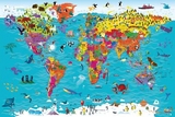
Colourful Illustrated Map of the World
This highly illustrated pictorial map is designed to take children on a journey of discovery around the countries of the world. The mapping is clear, colourful and highly informative and shows countries and capital cities.
Stunning illustrations are used to depict themes such as national emblems, customs, food, birds, animals, buildings and sports to help younger readers gain an understanding of peoples around the world.
Dimensions 610 X 915 mm
Illustrated by Steve Evans.
Steve has many years professional experience of collaborative practice with the major educational publishers, editors, in-house designers and authors. His creative practice includes illustration, logo design, cover design and full series design including online resource. His primary passion is for children’s illustration and this is demonstrated in his creation of the new Collins Picture Atlas alongside the accompanying World Map and, more recently, the map of the United Kingdom & Ireland.
| Erscheint lt. Verlag | 23.4.2015 |
|---|---|
| Illustrationen | Steve Evans |
| Verlagsort | London |
| Sprache | englisch |
| Maße | 900 x 600 mm |
| Gewicht | 40 g |
| Themenwelt | Schulbuch / Wörterbuch |
| ISBN-10 | 0-00-811473-0 / 0008114730 |
| ISBN-13 | 978-0-00-811473-2 / 9780008114732 |
| Zustand | Neuware |
| Haben Sie eine Frage zum Produkt? |