


Collins Children’s World Map
2010
Collins (Verlag)
978-0-00-735273-9 (ISBN)
Collins (Verlag)
978-0-00-735273-9 (ISBN)
- Titel erscheint in neuer Auflage
- Artikel merken
Zu diesem Artikel existiert eine Nachauflage
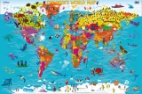
Colourful Illustrated Map of the World
A beautifully illustrated map of the world, designed to take children on an exciting journey around the countries of the world.
Stunning illustrations are used with a clear colourful world political map to depict customs, animals, buildings, sport, landmarks etc., to help younger readers gain an understanding of peoples and places around the world.
Facts are included about each continent to give children an insight into the way of life of people in far away lands.
Explore the world through maps..
| Erscheint lt. Verlag | 29.4.2010 |
|---|---|
| Reihe/Serie | Collins Primary Atlases |
| Verlagsort | London |
| Sprache | englisch |
| Gewicht | 80 g |
| Themenwelt | Schulbuch / Wörterbuch |
| ISBN-10 | 0-00-735273-5 / 0007352735 |
| ISBN-13 | 978-0-00-735273-9 / 9780007352739 |
| Zustand | Neuware |
| Haben Sie eine Frage zum Produkt? |