


Road Map Great Britain and Ireland
Sheet 6 – Ireland
1999
|
Revised edition
Collins (Verlag)
978-0-00-448824-0 (ISBN)
Collins (Verlag)
978-0-00-448824-0 (ISBN)
- Titel erscheint in neuer Auflage
- Artikel merken
Zu diesem Artikel existiert eine Nachauflage
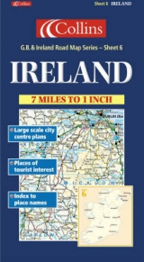
1:440,000 7.2 miles to 1 inch The Ireland sheet of a 6 sheet series of the British Isles. This sheet covers the whole of Ireland.
MAIN FEATURES
• New Collins mapping with hillshading
• Clear, colourful mapping at 7.2 miles to 1 inch
• Centre plans of Dublin, Belfast, Cork and Limerick
• Full index to place names
• All roads colour classified
INCLUDES
• Places of tourist information included
• Ferry routes & airports shown
• Distances shown on roads
AREA OF COVERAGE
Covers the whole of Ireland
WHO THE PRODUCT IS AIMED AT
This map is ideal for wall mounting or for use in the vehicle and is suitable for both business or pleasure motoring.
OTHER PRODUCTS IN THE SERIES
This map is part of a 6 sheet series covering the whole of Britain & Ireland. The other maps in the series are:
Sheet 1. Southern England – 0 00 448819 9
Sheet 2. South West England & Wales – 0 00 448820 2
Sheet 3. Northern England – 0 00 448821 0
Sheet 4. Central & Southern Scotland – 0 00 448822 9
Sheet 5. Northern Scotland – 0 00 448823 7
| Erscheint lt. Verlag | 4.1.1999 |
|---|---|
| Zusatzinfo | ch. |
| Verlagsort | London |
| Sprache | englisch |
| Maße | 145 x 257 mm |
| Gewicht | 121 g |
| Themenwelt | Reisen ► Karten / Stadtpläne / Atlanten ► Europa |
| ISBN-10 | 0-00-448824-5 / 0004488245 |
| ISBN-13 | 978-0-00-448824-0 / 9780004488240 |
| Zustand | Neuware |
| Haben Sie eine Frage zum Produkt? |
Mehr entdecken
aus dem Bereich


aus dem Bereich
Karte (gefalzt) (2023)
Freytag-Berndt und ARTARIA (Verlag)
12,90 €
Straßen- und Freizeitkarte 1:250.000
Karte (gefalzt) (2023)
Freytag-Berndt und ARTARIA (Verlag)
12,90 €
Östersund
Karte (gefalzt) (2023)
Freytag-Berndt und ARTARIA (Verlag)
12,90 €