Lake District: High Level and Fell Walks
Cicerone Press (Verlag)
978-1-85284-735-7 (ISBN)
- Titel ist leider vergriffen;
keine Neuauflage - Artikel merken
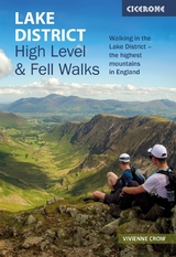
This guidebook to walking the highest mountains in the Lake District includes 30 high level and fell walks including Scafell Pike, Helvellyn, Skiddaw, and the Fairfield Horseshoe. Covering some of England's finest and highest mountain scenery, in the UK's most popular national park, this guide features classic routes as well as quieter favourites.
The 30 walks are divided into 6 sections, covering the best walking in the Lake District: the Keswick area, Borrowdale and Buttermere, the Western Valleys, Coniston and Langdale, Ambleside, Grasmere and Windermere, or Ullswater. From 7-23km and graded for difficulty, the walks combine Lakeland classics with lesser-known adventures. From classic horseshoes, such as the Newlands Round and the Fairfield Horseshoe, and traditional ascents of England's most iconic mountains, including its highest peaks Scafell Pike, Scafell, Helvellyn and Skiddaw, to routes onto some of the quieter summits including Gray Crag and Beda Fell, or quieter routes onto popular fells including Blencathra and Red Screes.
The guidebook includes OS map extracts, variant routes and lots of information to enhance your walking, from historical, geological and wildlife detail, to advice on travelling to and around the Lake District, and how to best prepare for an excellent day out on the fells.
Londoner by birth, but Cumbrian by choice, Vivienne Crow is an award-winning writer and photographer. Based near the Lake District, she has written more than a dozen guides to the national park and writes popular walking columns that appear in several north Cumbrian newspapers.
Introduction
The high fells
Geology
Wildlife and habitats
History
Weather
Where to stay
Getting around
Waymarking and access
Maps
Clothing, equipment and safety
Using this guide
The Walks
Walk 1 Skiddaw via Ullock Pike
Walk 2 Blencathra and its neighbours
Walk 3 Coledale Horseshoe
Walk 4 Newlands Round
Walk 5 Causey Pike, Knott Rigg and Robinson
Walk 6 Helvellyn range, end to end
Walk 7 Scafell Pike
Walk 8 Glaramara and Allen Crags
Walk 9 Great Gable (from Honister)
Walk 10 Hay Stacks
Walk 11 Grasmoor and Gasgale Crags
Walk 12 The High Stile ridge
Walk 13 Great Gable (from Wasdale Head)
Walk 14 Pillar and Red Pike
Walk 15 Scafell
Walk 16 The Coniston Fells
Walk 17 The Langdale Pikes
Walk 18 Pike o' Blisco and Crinkle Crags
Walk 19 Bow Fell and the Mickleden Round
Walk 20 Fairfield Horseshoe
Walk 21 Helm Crag and Blea Rigg
Walk 22 Kentmere Round
Walk 23 Helvellyn via the edges
Walk 24 Deepdale Round
Walk 25 Caiston Glen Round
Walk 26 Hartsop Dodd and Gray Crag
Walk 27 High Street and Harter Fell
Walk 28 A Martindale Round
Walk 29 Place Fell and Beda Fell
Walk 30 Matterdale and the Dodds
Appendices
Appendix A
Route summary table
Appendix B
96
800x600
Normal
0
false
false
false
EN-GB
JA
X-NONE
/* Style Definitions */
table.MsoNormalTable
{mso-style-name:"Table Normal";
mso-tstyle-rowband-size:0;
mso-tstyle-colband-size:0;
mso-style-noshow:yes;
mso-style-priority:99;
mso-style-parent:"";
mso-padding-alt:0cm 5.4pt 0cm 5.4pt;
mso-para-margin:0cm;
mso-para-margin-bottom:.0001pt;
mso-pagination:widow-orphan;
font-size:10.0pt;
font-family:Calibri;}
Useful contacts
| Erscheint lt. Verlag | 9.6.2021 |
|---|---|
| Reihe/Serie | Cicerone guidebooks |
| Zusatzinfo | 33 maps, 132 colour photographs |
| Verlagsort | Kendal |
| Sprache | englisch |
| Maße | 116 x 172 mm |
| Gewicht | 250 g |
| Themenwelt | Sachbuch/Ratgeber ► Sport |
| Reisen ► Sport- / Aktivreisen ► Europa | |
| ISBN-10 | 1-85284-735-2 / 1852847352 |
| ISBN-13 | 978-1-85284-735-7 / 9781852847357 |
| Zustand | Neuware |
| Haben Sie eine Frage zum Produkt? |
aus dem Bereich