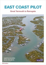
East Coast Pilot
Imray, Laurie, Norie & Wilson Ltd (Verlag)
978-1-84623-953-3 (ISBN)
- Titel erscheint in neuer Auflage
- Artikel merken
East Coast Pilot has become the bible for cruising sailors for the waters between Great Yarmouth and Ramsgate. Not only does it cover the many harbours, rivers and creeks in a clear and concise manner, it also reveals some of the mysteries of sailing these shallow and shifting coastal waters. Both authors keep their boats on the East Coast and are life-long lovers of the area. They maintain that every time they cast off and take to the water, they learn something new, adding to the considerable wealth of experience which they have passed on enthusiastically over many years.
For clarity and ease of reference the book is laid out in a logical sequence; each estuary, river and port has its own chapter which starts with the key information to get you in to that chosen destination. Box panels give key waypoints, port and harbour contact details, plus information about the main boating facilities a crew could need. Further pages will entice you in as far as the limit of navigation. Essential information is backed up by Imray cartography, the authors' own sea-level photography giving you a clear view of what you should see, and aerial photographs which offer a useful visual perspective on what
lies ahead.
Unique to East Coast Pilot are `rolling road' diagrams to guide the approach. These were introduced to great acclaim in the first edition and show buoyage sequences and tracks to steer into rivers and ports.
Updates are published on the dedicated website
Imray Laurie Norie & Wilson Ltd was formed in 1904 when three private chart publishing firms amalgamated. Each of these London companies had a long history going back to the mid-18th century. James Imray and Son published an extensive list of charts and pilot books. RH Laurie and Sons was associated with charts published for the East India Company. Norie and Wilson, founded by JW Norie, whose Nautical Tables are still supplied to navigators across the world, produced charts and books on navigation and sold nautical instruments.Until 1939 we were based in the City of London, where long serving cartographers produced charts from copper plate engravings which were supplied to mariners throughout the World. For over a century Blueback Charts were the first choice of many shipping companies. Now based in St Ives in Cambridgeshire, Imray charts are produced digitally for printed and electronic editions by our drawing office team. Our catalogue of yachting charts is regarded by the sailing community as the most comprehensive available. Our paper charts are complemented by a growing list of electronic publications and high quality pilot books by leading authors.
| Erscheinungsdatum | 23.08.2019 |
|---|---|
| Verlagsort | Huntingdon |
| Sprache | englisch |
| Maße | 297 x 210 mm |
| Themenwelt | Natur / Technik ► Fahrzeuge / Flugzeuge / Schiffe ► Schiffe |
| Sachbuch/Ratgeber ► Sport ► Segeln / Tauchen / Wassersport | |
| Technik ► Fahrzeugbau / Schiffbau | |
| ISBN-10 | 1-84623-953-2 / 1846239532 |
| ISBN-13 | 978-1-84623-953-3 / 9781846239533 |
| Zustand | Neuware |
| Haben Sie eine Frage zum Produkt? |
aus dem Bereich


