


Philip's World Wall Map
School Edition
Seiten
2008
Philip's (Verlag)
978-0-540-09462-2 (ISBN)
Philip's (Verlag)
978-0-540-09462-2 (ISBN)
- Titel erscheint in neuer Auflage
- Artikel merken
Zu diesem Artikel existiert eine Nachauflage
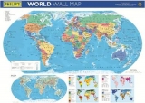
Political colours make it easy to identify individual countries. Clear type is easy to read from a distance. Wall map laminated for protection from stains and rips. Supplied rolled into a clear plastic tube - no folds or creases. Published in association with The Royal Geographical Society.
Philip's World Wall Map shows the whole of the World in political colours at a scale of 1:37.3M (1 cm on the map = 373 km on the ground), with clear lettering and symbols for easy reference. Individual countries are picked out in distinctive colours to aid identification, with city and town names clearly shown, as well as rivers and sea contours.Beneath the main map is a physically coloured map of the World at a scale of 1:92.6M (1 cm on the map = 926 km on the ground), showing rivers, hills and mountains, together with smaller thematic maps covering the important topics of population, wealth, climate regions and natural vegetation.Philip's World Wall Map is supplied laminated on one side and rolled into a clear plastic tube. It is ideal for mounting on a classroom wall or for use at home. The clarity of the map detail ensures that it is highly accessible for children, teachers and parents alike.Main map projection: Winkel Tripel.
Philip's World Wall Map shows the whole of the World in political colours at a scale of 1:37.3M (1 cm on the map = 373 km on the ground), with clear lettering and symbols for easy reference. Individual countries are picked out in distinctive colours to aid identification, with city and town names clearly shown, as well as rivers and sea contours.Beneath the main map is a physically coloured map of the World at a scale of 1:92.6M (1 cm on the map = 926 km on the ground), showing rivers, hills and mountains, together with smaller thematic maps covering the important topics of population, wealth, climate regions and natural vegetation.Philip's World Wall Map is supplied laminated on one side and rolled into a clear plastic tube. It is ideal for mounting on a classroom wall or for use at home. The clarity of the map detail ensures that it is highly accessible for children, teachers and parents alike.Main map projection: Winkel Tripel.
| Erscheint lt. Verlag | 19.5.2008 |
|---|---|
| Verlagsort | London |
| Sprache | englisch |
| Maße | 2 x 2 mm |
| Gewicht | 100 g |
| Themenwelt | Schulbuch / Wörterbuch |
| ISBN-10 | 0-540-09462-5 / 0540094625 |
| ISBN-13 | 978-0-540-09462-2 / 9780540094622 |
| Zustand | Neuware |
| Informationen gemäß Produktsicherheitsverordnung (GPSR) | |
| Haben Sie eine Frage zum Produkt? |
Mehr entdecken
aus dem Bereich

aus dem Bereich
Buch | Softcover (2024)
Community Editions (Verlag)
14,00 €
Brilliant Answers to Baffling Questions
Buch | Hardcover (2024)
DK Children (Verlag)
21,15 €