


Philip's Europe Wall Map
Seiten
2005
|
School edition
Philip's (Verlag)
978-0-540-08802-7 (ISBN)
Philip's (Verlag)
978-0-540-08802-7 (ISBN)
- Titel erscheint in neuer Auflage
- Artikel merken
Zu diesem Artikel existiert eine Nachauflage
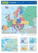
Cyprus, the Czech Republic, Estonia, Hungary, Latvia, Lithuania, Malta, Poland, the Slovak Republic and Slovenia all joined the EU in May 2004. Fully updated to reflect this expansion, this brightly coloured wall chart shows the whole of Europe in political colours, with clear lettering and symbols for easy reference. Individual countries are picked out in bright distinctive colours to aid identification, with town and city names clearly shown. Also included on the chart beneath the large political map is a physical map of Europe (at a scale of 1: 15 000 000, or 240 miles to 1 inch), together with smaller thematic maps on: the newly expanded European Union, rainfall, population, and transport. Philip's Europe Wall Map is supplied laminated on one side and rolled into a clear plastic tube. It is ideal for mounting on a bedroom wall or in the classroom the clarity of the mapping ensures that it is highly accessible for both parents and children alike.
| Erscheint lt. Verlag | 14.3.2005 |
|---|---|
| Reihe/Serie | Philip's Wall Maps |
| Zusatzinfo | M. |
| Verlagsort | London |
| Sprache | englisch |
| Maße | 2 x 2 mm |
| Gewicht | 350 g |
| Themenwelt | Schulbuch / Wörterbuch |
| ISBN-10 | 0-540-08802-1 / 0540088021 |
| ISBN-13 | 978-0-540-08802-7 / 9780540088027 |
| Zustand | Neuware |
| Haben Sie eine Frage zum Produkt? |
Mehr entdecken
aus dem Bereich

aus dem Bereich
Buch | Softcover (2024)
Community Editions (Verlag)
14,00 €
Geometrie und Rechnen mit Größen
Buch | Hardcover (2024)
Kallmeyer (Verlag)
29,95 €