Philip's Night Sky Atlas
Seiten
2017
Philip's (Verlag)
978-1-84907-444-5 (ISBN)
Philip's (Verlag)
978-1-84907-444-5 (ISBN)
- Titel ist leider vergriffen;
keine Neuauflage - Artikel merken
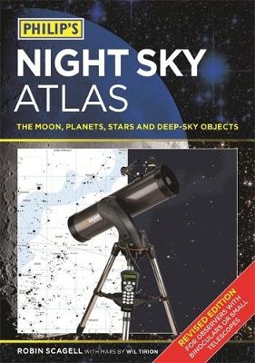
Fully revised and now in its third edition, Philip's Night Sky Atlas is a highly practical star atlas that can be used anywhere in the world and at any time of the year. With a sturdy, damp-proof binding, it is the ideal choice for the backyard astronomer using binoculars or a small telescope. It contains all the maps you need to learn your way around the night sky, whether you want to find remote galaxies, sketch lunar craters or make estimates of variable stars. Author Robin Scagell explains what you can see, what equipment (if any) you will need and how to make the most of your time under the stars. The star maps are by Wil Tirion, the world-renowned celestial cartographer.
The eight sky maps together show the whole of the night sky. Stars down to magnitude 5.5 are marked, together with the brighter deep-sky objects. They are drawn on a white background so that you can add your own pencil notes or observations to the maps. Opposite each of the sky maps is a photo-realistic version of the same map. In addition, constellation maps show numerous deep-sky targets, with interesting objects described in detail.
A Moon map, split into quadrants, is accompanied by suggestions of what to look for, with images of the most interesting features. The author also describes how to observe and record the planets, the Sun, meteors, eclipses, comets and deep-sky objects.
Robin Scagell (Author) Robin Scagell is a long-serving Vice President of Britain's Society for Popular Astronomy. A lifelong stargazer, he has worked as an observer and photographer, and as a journalist has edited a wide range of popular-interest magazines. Robin is the author of several popular astronomy books, and has contributed to many other publications. He has been awarded the Sir Arthur Clarke Award for Space Reporting in recognition of his many appearances on TV and radio talking about astronomy and space. Wil Tirion (Illustrator) Wil Tirion, who lives in the Netherlands, is the most highly regarded cartographer of celestial maps and charts in the world today.
| Erscheinungsdatum | 30.01.2017 |
|---|---|
| Illustrationen | Wil Tirion |
| Verlagsort | London |
| Sprache | englisch |
| Maße | 214 x 303 mm |
| Gewicht | 612 g |
| Themenwelt | Sachbuch/Ratgeber ► Natur / Technik ► Weltraum / Astronomie |
| Schulbuch / Wörterbuch ► Lexikon / Chroniken | |
| ISBN-10 | 1-84907-444-5 / 1849074445 |
| ISBN-13 | 978-1-84907-444-5 / 9781849074445 |
| Zustand | Neuware |
| Haben Sie eine Frage zum Produkt? |
Mehr entdecken
aus dem Bereich
aus dem Bereich
die Suche nach der Urkraft des Universums
Buch | Hardcover (2023)
Klett-Cotta (Verlag)
25,00 €
Perspektiven auf die Menschheit
Buch | Hardcover (2024)
Klett-Cotta (Verlag)
25,00 €


