


Collins World Wall Paper Map
2010
|
New edition
Collins (Verlag)
978-0-00-732687-7 (ISBN)
Collins (Verlag)
978-0-00-732687-7 (ISBN)
- Titel erscheint in neuer Auflage
- Artikel merken
Zu diesem Artikel existiert eine Nachauflage
FLAT PAPER EDITION
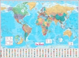
A new, updated edition of an ideal reference map covering the whole world, showing the political units on each continent. Includes national flags and key statistics for every country.
Scale 1:22 000 000
MAIN FEATURES
Fully updated political map showing individual countries and includes roads, railways, cities and towns, and physical features. Inset maps of the polar regions, national flags and key statistics for each country.
AREA OF COVERAGE
All of the world, centred on the Greenwich Meridian.
WHO THE PRODUCT IS AIMED AT
Home and business user as well as educational use.
OTHER VERSIONS AVAILABLE
Flat map, laminated in tube (978-0-00-821156-1)
| Erscheint lt. Verlag | 1.4.2010 |
|---|---|
| Verlagsort | London |
| Sprache | englisch |
| Maße | 1380 x 1015 mm |
| Gewicht | 20 g |
| Themenwelt | Reisen ► Karten / Stadtpläne / Atlanten ► Welt / Arktis / Antarktis |
| Schulbuch / Wörterbuch | |
| ISBN-10 | 0-00-732687-4 / 0007326874 |
| ISBN-13 | 978-0-00-732687-7 / 9780007326877 |
| Zustand | Neuware |
| Informationen gemäß Produktsicherheitsverordnung (GPSR) | |
| Haben Sie eine Frage zum Produkt? |
Mehr entdecken
aus dem Bereich

aus dem Bereich
Karte (plano) (2025)
Freytag-Berndt und ARTARIA (Verlag)
689,90 €