


Collins World Wall Laminated Map
2010
|
New edition
Collins (Verlag)
978-0-00-732688-4 (ISBN)
Collins (Verlag)
978-0-00-732688-4 (ISBN)
- Titel erscheint in neuer Auflage
- Artikel merken
Zu diesem Artikel existiert eine Nachauflage
LARGE, FLAT LAMINATED (on front side only) EDITION (102 x 138 cm, 40 x 54 inches)
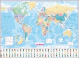
A new, updated edition of this ideal reference map covering the whole world, showing the political units on each continent. Includes national flags and key statistics for every country.
Scale 1:22 000 000; 1 cm to 220 km; 1 inch to 347 miles
MAIN FEATURES
Fully updated political map showing individual countries and includes roads, railways, cities and towns, and physical features. Inset maps of the polar regions, national flags and key statistics for each country.
AREA OF COVERAGE
All of the world, centred on the Greenwich Meridian.
The map is printed on high quality paper and laminated - ideal for any classroom, bedroom or office wall.
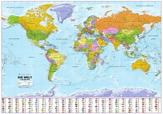
| Erscheint lt. Verlag | 4.3.2010 |
|---|---|
| Verlagsort | London |
| Sprache | englisch |
| Maße | 1380 x 1015 mm |
| Gewicht | 296 g |
| Themenwelt | Reisen ► Karten / Stadtpläne / Atlanten ► Welt / Arktis / Antarktis |
| Schulbuch / Wörterbuch | |
| ISBN-10 | 0-00-732688-2 / 0007326882 |
| ISBN-13 | 978-0-00-732688-4 / 9780007326884 |
| Zustand | Neuware |
| Haben Sie eine Frage zum Produkt? |
Mehr entdecken
aus dem Bereich

aus dem Bereich
1:30 Mio. mit Posterleisten, mit Oberflächenlaminat
Karte (gerollt) (2023)
INTERKART Landkarten & Globen (Verlag)
25,90 €