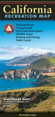
CALIFORNIA RECREATION MAP
2022
Benchmark Road & Recreation Atlases (Verlag)
978-0-7834-9929-1 (ISBN)
Benchmark Road & Recreation Atlases (Verlag)
978-0-7834-9929-1 (ISBN)
- Titel nicht im Sortiment
- Artikel merken
This folded map of the Golden State is the ideal companion to the California Road & Recreation Atlas. The entire state is shown on one side and is enhanced with enlargements of the Redwood Coast, Napa/Sonoma, Lake Tahoe, Yosemite Valley, Monterey, Santa Barbara, and Palm Springs areas. The reverse side of the sheet includes a Recreation Guide with categorized attractions including:
National Parks, Recreation Areas, Monuments, and Historic Sites
Selected State Parks & Recreation Areas
National Forests, Wildlife Refuges, and Wilderness Areas
Boating & Fishing Access
Selected Hiking Trails, Natural Wonders, and Ski Areas
Selected Campgrounds by Land Management Type
ISBN: 9780783499291 Cover:4″ x 9″ Sheet: 27″ x 35.75″
Map scale 1:1,318,821
| Erscheint lt. Verlag | 1.6.2022 |
|---|---|
| Sprache | englisch |
| Maße | 100 x 225 mm |
| Themenwelt | Sachbuch/Ratgeber ► Sport |
| Reisen ► Karten / Stadtpläne / Atlanten ► Nord- / Mittelamerika | |
| ISBN-10 | 0-7834-9929-9 / 0783499299 |
| ISBN-13 | 978-0-7834-9929-1 / 9780783499291 |
| Zustand | Neuware |
| Haben Sie eine Frage zum Produkt? |
Mehr entdecken
aus dem Bereich
aus dem Bereich
Karte (gefalzt) (2024)
Freytag-Berndt und ARTARIA (Verlag)
12,90 €
Karte (gefalzt) (2023)
Reise Know-How (Verlag)
12,00 €
Karte (gefalzt) (2023)
Reise Know-How (Verlag)
12,00 €


