


Pennine Cycleway North Pennines
Sustrans Official Map and Guide to the 150 Mile Cycle Route from Appleby-in-Westmorland or Penrith to Berwick-upon-Tweed
Seiten
2004
Sustrans (Verlag)
978-1-901389-48-7 (ISBN)
Sustrans (Verlag)
978-1-901389-48-7 (ISBN)
- Titel erscheint in neuer Auflage
- Artikel merken
Zu diesem Artikel existiert eine Nachauflage
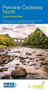
This 150 mile cycle route takes in some of the most spectacular landscapes and unspoilt countryside that England has to offer. Fold-out, full colour, waterproof map in splash-proof plastic sleeve. Easy to read contours and route profiles. Detailed routes through towns with essential visitor information.
This 150 mile cycle route takes in some of the most spectacular landscapes and unspoilt countryside that England has to offer. The route will take you through green and pleasant Eden Vallely, the dramatic North Pennines, the south Tyne Valley, past Hadrian's Wall World Heritage Site, and through Northumberland National Park and the foothills of the Cheviots. Finally you wend your way through the Scottish Boarders to end at the historic border town of Berwick-upon-Tweed on the magnificent Northumberland coast.
This 150 mile cycle route takes in some of the most spectacular landscapes and unspoilt countryside that England has to offer. The route will take you through green and pleasant Eden Vallely, the dramatic North Pennines, the south Tyne Valley, past Hadrian's Wall World Heritage Site, and through Northumberland National Park and the foothills of the Cheviots. Finally you wend your way through the Scottish Boarders to end at the historic border town of Berwick-upon-Tweed on the magnificent Northumberland coast.
| Erscheint lt. Verlag | 1.1.2004 |
|---|---|
| Zusatzinfo | full colour illustrations |
| Verlagsort | Bristol |
| Sprache | englisch |
| Maße | 125 x 235 mm |
| Themenwelt | Sachbuch/Ratgeber ► Sport ► Motor- / Rad- / Flugsport |
| Reisen ► Karten / Stadtpläne / Atlanten ► Europa | |
| ISBN-10 | 1-901389-48-0 / 1901389480 |
| ISBN-13 | 978-1-901389-48-7 / 9781901389487 |
| Zustand | Neuware |
| Haben Sie eine Frage zum Produkt? |
Mehr entdecken
aus dem Bereich
![Uckermark, 1:75.000 [offizielle Karte des ADFC, Allgemeiner Deutscher Fahrrad-Club] - ADFC - Allgemeiner Deutscher Fahrrad-Club e.V.](/media/107442469)

aus dem Bereich
Karte (gefalzt) (2023)
BVA BikeMedia (Verlag)
10,95 €
Karte (gefalzt) (2023)
BVA BikeMedia (Verlag)
11,95 €
4in1 Wanderkarte : mit Aktiv Guide und Detailkarten : inklusive Karte …
Karte (gefalzt) (2023)
Kompass-Karten (Verlag)
12,95 €