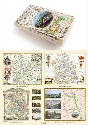
A Shropshire 1611 – 1836 – Fold Up Map that features a collection of Four Historic Maps, John Speed’s County Map 1611, Johan Blaeu’s County Map of 1648, Thomas Moules County Map of 1836 and a Map of the Severn Valley Railway in 1887.The maps also feature a number of early views across Shropshire including the famous Ironbridge over the Severn and the Severn at Bridgnorth.
Seiten
2019
Mapseeker Archive Publishing (Verlag)
978-1-84491-844-7 (ISBN)
Mapseeker Archive Publishing (Verlag)
978-1-84491-844-7 (ISBN)
This folded map (890mm x 1000mm when unfolded) is an ideal souvenir for tourists to Shropshire and also a valuable reference resource for local and family history research. It includes 4 Historic maps of Shropshire.
This folded map (890mm x 1000mm when unfolded) is an ideal souvenir for tourists to Shropshire and also a valuable reference resource for local and family history research. It includes 4 Historic maps of Shropshire, John Speed's County Map of Shropshire 1611, Johan Blaeu's County Map of Shropshire 1648, Thomas Moule's County Map of Shropshire 1836 and a Map of Shropshire detailing the route of the Severn Vale Railway 1889. All the maps have been meticulously re-produced from antique originals and printed on 90 gsm "Progeo" paper which was specially developed as a map paper. It has high opacity to help reduce show through and a cross grain giving it greater durability to as the map is being folded.
This folded map (890mm x 1000mm when unfolded) is an ideal souvenir for tourists to Shropshire and also a valuable reference resource for local and family history research. It includes 4 Historic maps of Shropshire, John Speed's County Map of Shropshire 1611, Johan Blaeu's County Map of Shropshire 1648, Thomas Moule's County Map of Shropshire 1836 and a Map of Shropshire detailing the route of the Severn Vale Railway 1889. All the maps have been meticulously re-produced from antique originals and printed on 90 gsm "Progeo" paper which was specially developed as a map paper. It has high opacity to help reduce show through and a cross grain giving it greater durability to as the map is being folded.
| Erscheinungsdatum | 24.12.2018 |
|---|---|
| Reihe/Serie | Historic English Counties Maps Collection ; 29 |
| Zusatzinfo | Historic Map Images |
| Verlagsort | Truro |
| Sprache | englisch |
| Maße | 134 x 227 mm |
| Themenwelt | Sachbuch/Ratgeber ► Geschichte / Politik ► Regional- / Landesgeschichte |
| Geisteswissenschaften ► Geschichte ► Hilfswissenschaften | |
| Naturwissenschaften ► Geowissenschaften ► Geografie / Kartografie | |
| ISBN-10 | 1-84491-844-0 / 1844918440 |
| ISBN-13 | 978-1-84491-844-7 / 9781844918447 |
| Zustand | Neuware |
| Haben Sie eine Frage zum Produkt? |
Mehr entdecken
aus dem Bereich
aus dem Bereich
Russen und Ukrainer vom Mittelalter bis zur Gegenwart
Buch | Softcover (2023)
C.H.Beck (Verlag)
18,00 €
von der Staatsgründung bis zur Gegenwart
Buch | Softcover (2023)
C.H.Beck (Verlag)
12,00 €


