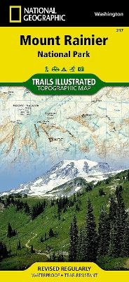
Mount Rainier National Park
Trails Illustrated National Parks
Seiten
2013
|
2022nd Revised ed.
National Geographic Maps (Verlag)
978-1-56695-345-0 (ISBN)
National Geographic Maps (Verlag)
978-1-56695-345-0 (ISBN)
- Titel z.Zt. nicht lieferbar
- Versandkostenfrei innerhalb Deutschlands
- Auch auf Rechnung
- Verfügbarkeit in der Filiale vor Ort prüfen
- Artikel merken
This Trails Illustrated topographic map is the most comprehensive recreational map for Washington's Mount Rainier National Park. Within the park, there is detailed coverage of Mount Rainier and its many glaciers; Eagles Roost, Cataract Valley, Mystic, Emmons Overlook, Indian Bar, Maple Creek, Snow Lake, Paradise River, Jackson and many other camping areas are also included. A detailed inset gives you a close-up view of the peak and trails leading to its glaciers. This map is printed on waterproof, tear-resistant material, ideal for the outdoors.
| Erscheint lt. Verlag | 26.9.2013 |
|---|---|
| Verlagsort | Evergreen |
| Sprache | englisch |
| Maße | 108 x 235 mm |
| Gewicht | 92 g |
| Einbandart | gefalzt |
| Themenwelt | Reisen ► Karten / Stadtpläne / Atlanten ► Nord- / Mittelamerika |
| ISBN-10 | 1-56695-345-6 / 1566953456 |
| ISBN-13 | 978-1-56695-345-0 / 9781566953450 |
| Zustand | Neuware |
| Haben Sie eine Frage zum Produkt? |
Mehr entdecken
aus dem Bereich
aus dem Bereich
Karte (gefalzt) (2024)
Freytag-Berndt und ARTARIA (Verlag)
12,90 €
Karte (gefalzt) (2023)
Reise Know-How (Verlag)
12,00 €
Karte (gefalzt) (2023)
Reise Know-How (Verlag)
12,00 €


