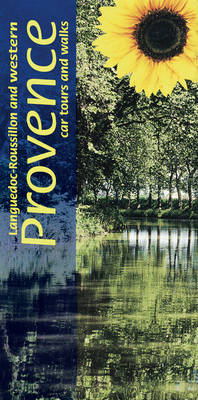
Landscapes of the Languedoc-Roussillon and Western Provence
Seiten
2009
|
3rd edition
Sunflower Books (Verlag)
978-1-85691-362-1 (ISBN)
Sunflower Books (Verlag)
978-1-85691-362-1 (ISBN)
- Titel erscheint in neuer Auflage
- Artikel merken
Zu diesem Artikel existiert eine Nachauflage
Pocket-sized full-colour guide describing car tours, walks and countryside picnics. Large-scale topographical walking maps (scale 1:50,000), fold-out touring map. Timetables for local transport. Unique free on-line update service with specific route change information. Series (50 destinations) dubbed 'the blue Bibles' by the Sunday Times.
12 car tours, over 50 long and short walks, 35 picnic suggestionsOne of a two-volume guide to Provence, intended for motorists who want to tour by car and enjoy some superb walks along the way. Beginning at Aix-en-Provence, you travel west via the Luberon and Mont Ventoux to the great Roman cities and the Pont du Gard. After forays north to the Ardeche, the Tarn and the Cirque de Navacelles, head south through Herault to Carcassonne and the Canal du Midi. Crossing the Corbieres and the Land of the Cathars, you reach the foot of Canigou, holy mountain of the Pyrenees.The touring routes have been described in such detail that there is no need to make constant reference to a map. The walks selected - all set in areas of great natural beauty or historical interest - are those the authors believe offer the greatest sense of satisfaction for the effort involved. They are mostly circular walks suitable for moderately fit people.Unusually for a 'Landscapes' guide, this book inludes recommended restaurants, with details of their menus.
12 car tours, over 50 long and short walks, 35 picnic suggestionsOne of a two-volume guide to Provence, intended for motorists who want to tour by car and enjoy some superb walks along the way. Beginning at Aix-en-Provence, you travel west via the Luberon and Mont Ventoux to the great Roman cities and the Pont du Gard. After forays north to the Ardeche, the Tarn and the Cirque de Navacelles, head south through Herault to Carcassonne and the Canal du Midi. Crossing the Corbieres and the Land of the Cathars, you reach the foot of Canigou, holy mountain of the Pyrenees.The touring routes have been described in such detail that there is no need to make constant reference to a map. The walks selected - all set in areas of great natural beauty or historical interest - are those the authors believe offer the greatest sense of satisfaction for the effort involved. They are mostly circular walks suitable for moderately fit people.Unusually for a 'Landscapes' guide, this book inludes recommended restaurants, with details of their menus.
| Erscheint lt. Verlag | 15.5.2009 |
|---|---|
| Reihe/Serie | Landscapes |
| Zusatzinfo | col. Illustrations, col. maps |
| Verlagsort | London |
| Sprache | englisch |
| Maße | 100 x 210 mm |
| Themenwelt | Reiseführer ► Europa ► Frankreich |
| ISBN-10 | 1-85691-362-7 / 1856913627 |
| ISBN-13 | 978-1-85691-362-1 / 9781856913621 |
| Zustand | Neuware |
| Haben Sie eine Frage zum Produkt? |
Mehr entdecken
aus dem Bereich
aus dem Bereich
individuell reisen mit vielen praktischen Tipps
Buch | Softcover (2024)
Michael Müller (Verlag)
22,90 €
individuell reisen mit vielen praktischen Tipps
Buch | Softcover (2024)
Michael Müller (Verlag)
21,90 €


