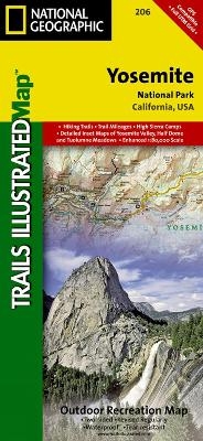
Yosemite National Park
Trails Illustrated National Parks
Seiten
2012
|
2019th ed.
National Geographic Maps (Verlag)
978-1-56695-299-6 (ISBN)
National Geographic Maps (Verlag)
978-1-56695-299-6 (ISBN)
Trails Illustrated topographic maps are the most detailed and up-to-date recreation maps available for these national parks, national forests and popular outdoor recreation areas. Coverage in this map includes: Stanislaus National Forest, Toiyabe National Forest, Inyo National Forest, Sierra National Forest Emigrant Wilderness, Carson Iceberg Wilderness, Hoover Wilderness, Yosemite Wilderness, and Ansel Adams Wilderness with detail on Yosemite Valley and Tuolumne Meadows. Also provides UTM grids for use with your GPS unit.
| Erscheint lt. Verlag | 2.8.2012 |
|---|---|
| Verlagsort | Evergreen |
| Sprache | englisch |
| Maße | 108 x 235 mm |
| Gewicht | 92 g |
| Einbandart | gefalzt |
| Themenwelt | Reisen ► Karten / Stadtpläne / Atlanten ► Nord- / Mittelamerika |
| ISBN-10 | 1-56695-299-9 / 1566952999 |
| ISBN-13 | 978-1-56695-299-6 / 9781566952996 |
| Zustand | Neuware |
| Haben Sie eine Frage zum Produkt? |
Mehr entdecken
aus dem Bereich
aus dem Bereich
Karte (gefalzt) (2024)
Freytag-Berndt und ARTARIA (Verlag)
12,90 €
Karte (gefalzt) (2023)
Reise Know-How (Verlag)
12,00 €
Karte (gefalzt) (2023)
Reise Know-How (Verlag)
12,00 €


