


The Times World Wall Laminated Map
2008
Times Books (Verlag)
978-0-00-727582-3 (ISBN)
Times Books (Verlag)
978-0-00-727582-3 (ISBN)
- Titel ist leider vergriffen;
keine Neuauflage - Artikel merken
Zu diesem Artikel existiert eine Nachauflage
LARGE FLAT LAMINATED EDITION (100 x 125 cm, 39.5 x 49 inches)
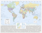
A new, updated edition of the authoritative Times Map of the World. It contains politically coloured mapping which shows countries clearly.
Scale 1:25 000 000; 1cm to 250 km; 1 inch to 395 miles
MAIN FEATURES
A politically coloured map of the world showing individual countries and their capital cities with principal roads and railways. Local name forms are used for all towns and cities with the English or historical alternative shown in brackets e.g. Mumbai (Bombay), Sankt Peterburg (Leningrad) where space permits. This makes the map readily accessible to the general reader who needs an up-to-date map to follow reports of world events in newspapers, on radio and television.
UPDATES INCLUDE
- New independent country of Kosovo
- New joint capital of Myanmar- Naypyidaw
- Golmud-Lhasa railway in Tibet now open
- Longest cross ocean bridge to the south of Shanghai
- Aral Sea continues to shrink in size
AREA OF COVERAGE
All of the world, centred on the Greenwich Meridian, and including maps of the North and South Pole regions.
INCLUDES
Index to names on the map with cross references to alternative and historical name forms.
| Erscheint lt. Verlag | 6.5.2008 |
|---|---|
| Zusatzinfo | colour |
| Verlagsort | London |
| Sprache | englisch |
| Maße | 1250 x 1000 mm |
| Gewicht | 239 g |
| Themenwelt | Reisen ► Karten / Stadtpläne / Atlanten ► Welt / Arktis / Antarktis |
| ISBN-10 | 0-00-727582-X / 000727582X |
| ISBN-13 | 978-0-00-727582-3 / 9780007275823 |
| Zustand | Neuware |
| Haben Sie eine Frage zum Produkt? |
Mehr entdecken
aus dem Bereich

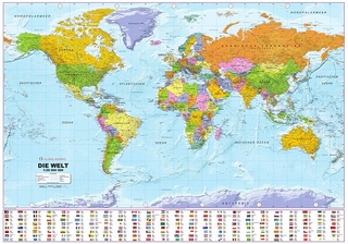
aus dem Bereich
1:30 Mio. mit Posterleisten, mit Oberflächenlaminat
Karte (gerollt) (2023)
INTERKART Landkarten & Globen (Verlag)
25,90 €