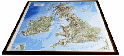
British Isles Raised Relief Map
Light Wood Frame
2007
Dorrigo (Verlag)
978-1-906473-07-5 (ISBN)
Dorrigo (Verlag)
978-1-906473-07-5 (ISBN)
- Titel ist leider vergriffen;
keine Neuauflage - Artikel merken
Covering Ireland and the Channel Islands, this map offers a presentation of rivers, roads, contours and spot heights.
Dorrigo raised relief maps are available framed in choice of dark or light solid wood moulding styles or without a frame for customers to choose a finish of their own. They are individually boxed for easy and safe transport and are ready to be wall mounted. The mapping is very accurate at a scale of 1:53,000 and offers a unique presentation of rivers, roads, contours and spot heights. The finished size is 825x740mm.The coverage includes Ireland and the Channel Islands.
Dorrigo raised relief maps are available framed in choice of dark or light solid wood moulding styles or without a frame for customers to choose a finish of their own. They are individually boxed for easy and safe transport and are ready to be wall mounted. The mapping is very accurate at a scale of 1:53,000 and offers a unique presentation of rivers, roads, contours and spot heights. The finished size is 825x740mm.The coverage includes Ireland and the Channel Islands.
| Reihe/Serie | Raised Relief Maps Series |
|---|---|
| Verlagsort | Manchester |
| Sprache | englisch |
| Themenwelt | Reisen ► Karten / Stadtpläne / Atlanten ► Europa |
| ISBN-10 | 1-906473-07-2 / 1906473072 |
| ISBN-13 | 978-1-906473-07-5 / 9781906473075 |
| Zustand | Neuware |
| Informationen gemäß Produktsicherheitsverordnung (GPSR) | |
| Haben Sie eine Frage zum Produkt? |
Mehr entdecken
aus dem Bereich
aus dem Bereich
Straßen- und Freizeitkarte 1:250.000
Karte (gefalzt) (2023)
Freytag-Berndt und ARTARIA (Verlag)
12,90 €
Baskenland, Navarra, Aragon, Andorra, Katalonien
Karte/Kartografie (2023)
MAIRDUMONT (Verlag)
11,95 €
Karte (gefalzt) (2024)
Freytag-Berndt und ARTARIA (Verlag)
12,90 €


