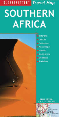
Southern Africa
2007
|
3rd Revised edition
New Holland Publishers Ltd (Verlag)
978-1-84537-994-0 (ISBN)
New Holland Publishers Ltd (Verlag)
978-1-84537-994-0 (ISBN)
- Titel erscheint in neuer Auflage
- Artikel merken
Zu diesem Artikel existiert eine Nachauflage
Part of a series which includes Travel Guides, Maps and Road Atlases, this title covers more than 80 destinations worldwide. It caters specifically for the needs of tourists who are new to a destination. Each map features colour photographs.
The highly successful "Globetrotter Travel" series, which includes Travel Guides, Maps and Road Atlases, presently covers more than 80 destinations worldwide."The Globetrotter Travel Map of Southern Africa" caters specifically for the needs of tourists who are new to a destination. Each map is attractively designed and features superb colour photographs. In addition to the main map of Southern Africa, the following areas of special interest to visitors are shown in greater detail such as: Town Plans: Cape Town; Johannesburg; Pretoria; Durban; Maputo; Gabarone; Windhoek; Swakopmund; Walvis Bay; Harare; Bulawayo.Areas covered include: Madagascar; Sun City; Kruger National Park; Around Johannesburg and Pretoria; Cape Peninsula and Winelands; Etosha National Park; Okavango Delta and Makgadikgadi Pans; Victoria Falls; Lake Kariba; Nyanga National Park; Hwange National Park; Fish River Canyon.The town plans of the major centres pinpoint key buildings and places of interest as well as where to stay. Distance and climate charts enable travellers to plan their visits, while stunning photographs evoke the atmosphere of Southern Africa.
The highly successful "Globetrotter Travel" series, which includes Travel Guides, Maps and Road Atlases, presently covers more than 80 destinations worldwide."The Globetrotter Travel Map of Southern Africa" caters specifically for the needs of tourists who are new to a destination. Each map is attractively designed and features superb colour photographs. In addition to the main map of Southern Africa, the following areas of special interest to visitors are shown in greater detail such as: Town Plans: Cape Town; Johannesburg; Pretoria; Durban; Maputo; Gabarone; Windhoek; Swakopmund; Walvis Bay; Harare; Bulawayo.Areas covered include: Madagascar; Sun City; Kruger National Park; Around Johannesburg and Pretoria; Cape Peninsula and Winelands; Etosha National Park; Okavango Delta and Makgadikgadi Pans; Victoria Falls; Lake Kariba; Nyanga National Park; Hwange National Park; Fish River Canyon.The town plans of the major centres pinpoint key buildings and places of interest as well as where to stay. Distance and climate charts enable travellers to plan their visits, while stunning photographs evoke the atmosphere of Southern Africa.
| Erscheint lt. Verlag | 25.10.2007 |
|---|---|
| Reihe/Serie | Globetrotter Travel Map |
| Zusatzinfo | 12 full colour photographs, 11 town plans, 12 area maps |
| Verlagsort | London |
| Sprache | englisch; französisch; deutsch |
| Maße | 125 x 250 mm |
| Themenwelt | Reisen ► Karten / Stadtpläne / Atlanten ► Afrika |
| ISBN-10 | 1-84537-994-2 / 1845379942 |
| ISBN-13 | 978-1-84537-994-0 / 9781845379940 |
| Zustand | Neuware |
| Haben Sie eine Frage zum Produkt? |
Mehr entdecken
aus dem Bereich
aus dem Bereich
Karte (gefalzt) (2024)
Freytag-Berndt und ARTARIA (Verlag)
12,90 €
Karte (gefalzt) (2023)
Freytag-Berndt und ARTARIA (Verlag)
12,90 €
reiß- und wasserfest (world mapping project)
Karte (gefalzt) (2024)
Reise Know-How (Verlag)
14,00 €


