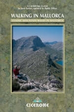
Walking in Mallorca
Cicerone Press (Verlag)
978-1-85284-488-2 (ISBN)
- Titel ist leider vergriffen;
keine Neuauflage - Artikel merken
A comprehensive walking guide to Mallorca. The 80 varied walking routes cover 4 areas around the island - Pollenca and the north, The Central Mountains, Andratx and the south, and the Serra de Llevant. It provides a selection of walks of all degrees of difficulty, and should enable even those limited to a short holiday to make the best use of their time. Circular walks have been described whenever possible, but sometimes it is necessary to return the same way to the starting point. Rugged mountain walks contrast with remote valleys, while waymarked trails give way to long-forgotten mule tracks and hidden mountain passes. Some walks run close to breathtaking cliff coastlines, while others pass through sleepy villages where welcome refreshment can be obtained. Reprinted in 2014 with updates.
Paddy Dillon is a prolific outdoor writer with over a score of books to his name. He lives on the fringe of the Lake District, and has walked, and written about walking, in every county in England, Scotland, Ireland and Wales. He has walked in many parts of Europe, as well as Nepal, Tibet and the Canadian Rockies
Mallorca - Location Map
Map Key
List of Sketch Maps
Routes List
Table of Mountains and Tops over 1000m
Preface to the Fourth Edition
Introduction
General Background, Scope of this Guide, Accommodation and Travel,
Choice of Base, Climate and Weather
Geology and Scenery
Brief Geological History, Surface Features Today
Natural History
Flora, Birds, Other Wildlife, the Parc Natural de s'Albufera, the Black Vulture
Recuperation Programme, Pine Processionary Caterpillars
Man and the Landscape
History, Cultivation, Rural Industries
Walking in Mallorca
Equipment and Clothing, Maps, Grading and Route Information,
Access, Walkers' Country Code, IBANAT, FODESMA, Mountain Rescue,
Guided Walking, Road Reclassification
Route Descriptions
Area 1 Pollença and the North
Area 2 The Central Mountains
Area 3 Andratx and the South
Area 4 Serra de Llevant and Randa
Appendices
Appendix 1 High Level Walk from Andratx to Pollença
Appendix 2 Alphabetical Reference Section
Appendix 3 Language Notes and Topographical Glossary
Appendix 4 Further Reading
| Erscheint lt. Verlag | 26.6.2014 |
|---|---|
| Zusatzinfo | 120 colour photos and 40 maps |
| Verlagsort | Kendal |
| Sprache | englisch |
| Maße | 116 x 172 mm |
| Gewicht | 460 g |
| Themenwelt | Sachbuch/Ratgeber ► Sport |
| Reiseführer ► Europa ► Spanien | |
| ISBN-10 | 1-85284-488-4 / 1852844884 |
| ISBN-13 | 978-1-85284-488-2 / 9781852844882 |
| Zustand | Neuware |
| Haben Sie eine Frage zum Produkt? |
aus dem Bereich


