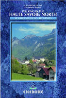
Walking in the Haute Savoie: North
Cicerone Press (Verlag)
978-1-85284-410-3 (ISBN)
- Titel ist leider vergriffen;
keine Neuauflage - Artikel merken
The Haute Savoie region of France lies in the southeast of the country below Lake Geneva. While the region is probably best known for its famous Mont Blanc range, this guide opens up to walkers the dozens of other, less frequented mountains in the Haute Savoie, which are just as delightful.
This guide is the first of a series of two volumes covering the walking possibilities in the Haute Savoie. This book describes 30 walks in the northern part of the region, which includes the gentle pre-alps south of Lake Geneva (Chablais, Salve and Valle Verte) across to the Swiss border. Book 2 covers the higher peaks to the south, between Annecy and Chamonix. Both volulmes of the guide also give historical background, descriptions of the different areas the walks start from, plus additional information regarding the towns and villages which can be used as centres. There are chapters concerning how to get there, equipment, walk explanations, flora and fauna.
Janette Norton has lived near Geneva for over 30 years working in marketing. Her love of mountains dates from being a guide in her twenties, and the proximity of the Alps and Jura to her home continued her passion. Now her family has grown up, she has branched out to explore other areas of France.
WALKS
Salève and Vallée Verte
Salève
1 Salève - Orjobet/Grande Gorge
2 Along the Top of the Salève
3 Cruseilles to L'Iselet
4 Pointe du Plan from St Blaise
5 Le Grand Piton
6 Le Vuache de Chaumont
Vallée Verte
7 Signal des Voirons
8 Mont de Vouan
9 Pointe de Miribel
10 Heights of Habère-Poche (Mont Forchat)
11 Around Villard
12 Montagne d'Hirmentaz
Chablais Region
Pré-Alp Area, south of Thonon/Evian
13 Mont Hermone
14 Pic des Mémises
15 Pic Boré
16 Pic Blanchard
17 La Dent d'Oche
Abondance Valley
18 Round Mont Chauffé
19 Roc de Tavaneuse
20 Les Cornettes de Bise
21 Lac d'Arvouin/Col de Vernaz
22 Pointe des Mattes
23 Mont de Grange
24 Le Morclan
Near Morzine
25 Col de Chésery
26 Pointe de Ressachaux
27 Col de Cou
Near Bellevaux
28 Pointe de la Gay
29 Grand Rocher de Nifflon
30 Pointe de Chalune
| Erscheint lt. Verlag | 11.11.2011 |
|---|---|
| Zusatzinfo | 50 colour photos and over 30 maps |
| Verlagsort | Kendal |
| Sprache | englisch |
| Maße | 116 x 172 mm |
| Gewicht | 260 g |
| Themenwelt | Sachbuch/Ratgeber ► Sport |
| Reiseführer ► Europa ► Frankreich | |
| ISBN-10 | 1-85284-410-8 / 1852844108 |
| ISBN-13 | 978-1-85284-410-3 / 9781852844103 |
| Zustand | Neuware |
| Haben Sie eine Frage zum Produkt? |
aus dem Bereich


