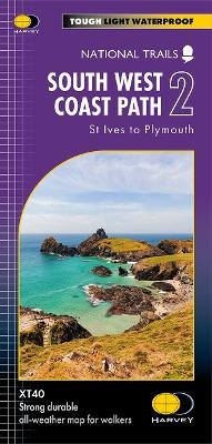
South West Coast Path 2
St Ives to Plymouth
Seiten
2024
Harvey Map Services Ltd (Verlag)
978-1-85137-682-7 (ISBN)
Harvey Map Services Ltd (Verlag)
978-1-85137-682-7 (ISBN)
The South West Coast path is a 1014km (630mile) long distance path and the longest National Trail in England.
The path stretches from Minehead in Somerset to Poole in Dorset, including Land?s End and Cornwall?s stunning south coast.
- This updated Trail Map covers the second section of the South West Coast Path from St Ives to Plymouth which is 282km (181.5 miles).
- The entire route on 3 sheets. This is map 2 of 3.
- A good two weeks? walking on one map.
- The XT40 is based on original HARVEY mapping with all the detail a walker would expect on a map at 1:40,000 scale.
- Clear and easy to read mapping which is uncluttered by information irrelevant to the walker.
- Printed on tough, light and 100% waterproof paper, less than half the weight of a laminated map.
- Shows facilities and services along the route.
| Erscheint lt. Verlag | 11.6.2024 |
|---|---|
| Reihe/Serie | Trail map |
| Verlagsort | Perthshire |
| Sprache | englisch |
| Maße | 115 x 245 mm |
| Gewicht | 60 g |
| Themenwelt | Reisen ► Karten / Stadtpläne / Atlanten |
| ISBN-10 | 1-85137-682-8 / 1851376828 |
| ISBN-13 | 978-1-85137-682-7 / 9781851376827 |
| Zustand | Neuware |
| Haben Sie eine Frage zum Produkt? |
Mehr entdecken
aus dem Bereich
aus dem Bereich
Karte/Kartografie (2024)
BVA BikeMedia (Verlag)
15,95 €
Karte (gefalzt) (2023)
Freytag-Berndt und ARTARIA (Verlag)
12,90 €
Karte (gerollt) (2023)
Freytag-Berndt und ARTARIA (Verlag)
24,90 €


