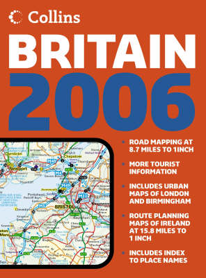
2006 Collins Handy Road Atlas Britain
Seiten
2005
|
New edition
Collins (Verlag)
978-0-00-719994-5 (ISBN)
Collins (Verlag)
978-0-00-719994-5 (ISBN)
- Titel gebraucht verfügbar
- Artikel merken
1:625,000 10 miles to 1 inch. The handy A5 format of this atlas makes it the ideal travelling companion. It has clear, detailed mapping and fits neatly into the glove box, pocket or bag.
MAIN FEATURES
• Mapping has been fully updated for 2006
• Clear attractive mapping of Britain at 10 miles to 1 inch
• Whole of Ireland included at 16 miles to 1 inch
• City maps of London & Birmingham at 4 miles to 1 inch
• Popular handy format in spiral binding
INCLUDES
• Full index to place names
• Attractive layer colouring
• Roads colour classified
• Places of tourist interest shown
• Distances between destinations marked
AREA OF COVERAGE
Covers the whole of Britain at 10 miles to 1 inch and Ireland at 16 miles to 1 inch
WHO THE PRODUCT IS OF INTEREST TO
Ideal general purpose route planner in a handy format. Fits easily in the glove box, briefcase, handbag or pocket, with popular spiral binding.
| Erscheint lt. Verlag | 1.8.2005 |
|---|---|
| Zusatzinfo | Index |
| Verlagsort | London |
| Sprache | englisch |
| Maße | 148 x 210 mm |
| Gewicht | 130 g |
| Themenwelt | Reisen ► Karten / Stadtpläne / Atlanten ► Europa |
| ISBN-10 | 0-00-719994-5 / 0007199945 |
| ISBN-13 | 978-0-00-719994-5 / 9780007199945 |
| Zustand | Neuware |
| Haben Sie eine Frage zum Produkt? |
Mehr entdecken
aus dem Bereich
aus dem Bereich
Buch | Hardcover (2012)
Westermann Schulbuchverlag
34,95 €
Schulbuch Klassen 7/8 (G9)
Buch | Hardcover (2015)
Klett (Verlag)
30,50 €
Buch | Softcover (2004)
Cornelsen Verlag
25,25 €


