Philip's Reference Map: United States
Political
Seiten
2004
Philip's (Verlag)
978-0-540-08716-7 (ISBN)
Philip's (Verlag)
978-0-540-08716-7 (ISBN)
- Titel ist leider vergriffen;
keine Neuauflage - Artikel merken
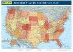
This brightly coloured wall chart shows the United States of America with clear lettering and symbols for easy reference.
New for 2004, this brightly coloured wall chart shows the United States of America with clear lettering and symbols for easy reference. Individual states are picked out in bright distinctive colours to aid identification, with major cities, towns, roads, railways, airports and rivers clearly shown. The map gives excellent coverage of the main transport network, and is useful for study, reference or travel planning.Accompanying the main map are two separate inset maps showing the states of Alaska and Hawaii.Philip's United States Reference Map (Political) is supplied folded with a tipped-on card cover for use when travelling.Main map scale:
New for 2004, this brightly coloured wall chart shows the United States of America with clear lettering and symbols for easy reference. Individual states are picked out in bright distinctive colours to aid identification, with major cities, towns, roads, railways, airports and rivers clearly shown. The map gives excellent coverage of the main transport network, and is useful for study, reference or travel planning.Accompanying the main map are two separate inset maps showing the states of Alaska and Hawaii.Philip's United States Reference Map (Political) is supplied folded with a tipped-on card cover for use when travelling.Main map scale:
| Erscheint lt. Verlag | 16.8.2004 |
|---|---|
| Verlagsort | London |
| Sprache | englisch |
| Maße | 147 x 263 mm |
| Gewicht | 97 g |
| Themenwelt | Reisen ► Karten / Stadtpläne / Atlanten ► Nord- / Mittelamerika |
| ISBN-10 | 0-540-08716-5 / 0540087165 |
| ISBN-13 | 978-0-540-08716-7 / 9780540087167 |
| Zustand | Neuware |
| Haben Sie eine Frage zum Produkt? |
Mehr entdecken
aus dem Bereich
aus dem Bereich

