


Collins Three Wall Maps
Colourful Poster Maps of the World and Uk
2009
Collins (Verlag)
978-0-00-733738-5 (ISBN)
Collins (Verlag)
978-0-00-733738-5 (ISBN)
- Titel ist leider vergriffen;
keine Neuauflage - Artikel merken
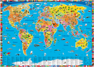
Three colourful poster maps in one pack. Poster map set containing a world political, world environmental and United Kingdom laminated map.
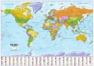
World Political Map: Ideal reference map covering the whole world, showing individual countries. Includes national flags and key statistics for every country.
World Environment Map: Satellite image of the world with physical names. Also includes fascinating images of environmental change affecting the planet.
United Kingdom Map: Detailed politically coloured road map of all of the United Kingdom. Statistics and flags shown for each of the home countries.
Explore the world through accurate and up-to-date mapping.
| Erscheint lt. Verlag | 6.8.2009 |
|---|---|
| Verlagsort | London |
| Sprache | englisch |
| Maße | 1104 x 812 mm |
| Gewicht | 458 g |
| Themenwelt | Reisen ► Karten / Stadtpläne / Atlanten ► Welt / Arktis / Antarktis |
| ISBN-10 | 0-00-733738-8 / 0007337388 |
| ISBN-13 | 978-0-00-733738-5 / 9780007337385 |
| Zustand | Neuware |
| Haben Sie eine Frage zum Produkt? |
Mehr entdecken
aus dem Bereich

aus dem Bereich
1:30 Mio. mit Posterleisten, mit Oberflächenlaminat
Karte (gerollt) (2023)
INTERKART Landkarten & Globen (Verlag)
25,90 €