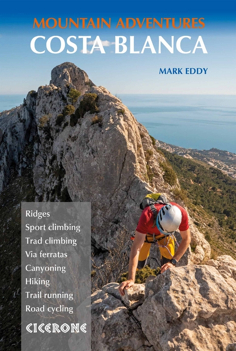
Costa Blanca Mountain Adventures
Cicerone Press (Verlag)
978-1-78631-033-0 (ISBN)
There are few destinations in Europe where you can enjoy typical 'summer' outdoor pursuits in the middle of winter. However, Spain's Costa Blanca is one such place and the range and quality of activities on offer is outstanding. This multi-activity guide presents a handpicked selection of 60 ridge routes, via ferratas, canyons, sport-climbing crags, trad-climbing crags, hikes, trail runs and road-cycling routes to inspire keen adventurers to explore the region's striking ridges, peaks, crags and barrancos (canyons). A broad spectrum of activities is covered - although since many of the routes involve climbing skills and rope-work, the guide is particularly well suited to climbers interested in a multi-activity holiday - and there are plenty of mid-grade options.
Although quieter in winter, Costa Blanca is well served for accommodation and facilities, with easy access from Alicante. The guide includes plenty of useful information to help you plan your holiday and directions to help you locate the start-point for each activity. All of the activities are clearly graded and include route description and mapping and - for the climbing routes and via ferratas - photo topos illustrating the line of the route. Handy tables summarise the key information, making it easy to choose an activity to suit. With inspiring colour photography to whet your appetite, Costa Blanca Mountain Adventures is the perfect companion to discovering the adventures that await in this bounteous region.
Mark Eddy is a mountain guide and outdoor activity instructor living in the English Lake District. He began climbing in the early 1990s and has put up a number of first ascents in the UK and Spain. Mark has been a regular visitor to south-east Spain for 30 years, always choosing the path less followed in the pursuit of adventure.
Regional overview map
Map key
Key to photo topos
Overview map 1: Ridges, via ferratas and canyons
Overview map 2: Sport and trad climbing
Overview map 3: Hiking, trail running and road cycling
Introduction
Landscape
Plants and wildlife
When to go
Getting there
Getting around
Accommodation
Food and drink
Language
Maps
Waymarking and access
Health and safety
Using this guide
Ridges
Route 1 Toix Ridge Integral (Este y Oeste)
Route 2 Bernia Ridge
Route 3 Sierra Ferrer Ridge
Route 4 Segaria Ridge
Route 5 Cresta del Migdia
Route 6 El Realet/Alt del Castellet
Route 7 Cresta del Canelobre, Cabezón de Oro
Route 8 Forada Ridge
Route 9 Benicadell Ridge
Route 10 Arista al Forat de la Forada
Route 11 Cresta dels Bardals, Serrella
Route 12 Cresta del Castellar
Route 13 Cresta del Maigmó
Via ferratas
Route 14 Penya del Figueret
Route 15 Ponoch (Ponoig)
Route 16 El Cid
Route 17 Redov&##xe1;n
Route 18 Callosa de Segura
Route 19 Castillo Salvatierra
Route 20 Aventador
Canyons
Route 21 Barranco del Pas de Tancat
Route 22 Barranco del Infierno
Route 23 Barranco dels Llidoners and de Racons
Route 24 Barranco del Pas de Calvo
Route 25 Barranco del Parent
Route 26 Barranco de l'Estret de Cardos
Route 27 Barranco de Mascarat
Route 28 Barranco del Curt o Pas de Bandolers
Sport climbing
Route 29 Alcalalí
Route 30 Los Cerezos
Route 31 Sierra de Toix
Route 32 Candelabra del Sol
Route 33 Morro Falquí
Route 34 Ambolo
Route 35 L'Atzúbia (Adsubia)
Route 36 Sector Cuevas, Cabezón de Oro
Trad climbing
Route 37 Aristotles and Pepsi Crest, Puig Campana
Route 38 Espolón Central, Puig Campana
Route 39 The Edwards Finish, Puig Campana
Route 40 Via Gene, Cabezón de Oro
Route 41 Arista Agullo, Cabezón de Oro
Route 42 Via Esther and Scorpion, Vall de Gulabdar
Route 43 Via Pany, El Peñón de Ifach
Hiking
Route 44 Mallada del Llop and El Regall
Route 45 Cova del Dalt and Es Crestall
Route 46 Xanchet circuit
Route 47 Bernia circuit and fort
Trail running
Route 48 Castell d'Axia
Route 49 Aixorta and Les Arcs
Route 50 Corral de la Llacuna
Route 51 Les Arcs and Raco Roig
Route 52 Castell de Granadella
Route 53 Sierra de Olta
Route 54 Puig Campana
Route 55 Penya Gros and Forada
Route 56 Barranco del Infierno circuit
Road cycling
Route 57 Col de Rates, Tarbena and Castell de Castells
Route 58 Vall de Gallinera and Vall d'Ebo
Route 59 Bernia circuit
Route 60 Serrella and Aitana circuit
Appendix A Activity summary table
Appendix B Useful contacts
Appendix C Castilian - Valencian - English glossary
Appendix D Further reading
Appendix E Climbing grades comparison table
| Erscheinungsdatum | 03.10.2022 |
|---|---|
| Reihe/Serie | Cicerone guidebooks |
| Zusatzinfo | 4 overview maps, 57 route maps, 42 photo topos and over 70 colour photos |
| Verlagsort | Kendal |
| Sprache | englisch |
| Maße | 116 x 172 mm |
| Gewicht | 330 g |
| Themenwelt | Sachbuch/Ratgeber ► Sport |
| Reisen ► Sport- / Aktivreisen ► Europa | |
| ISBN-10 | 1-78631-033-3 / 1786310333 |
| ISBN-13 | 978-1-78631-033-0 / 9781786310330 |
| Zustand | Neuware |
| Haben Sie eine Frage zum Produkt? |
aus dem Bereich


