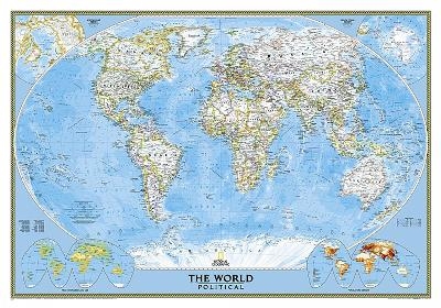
World Classic, Tubed
Wall Maps World
Seiten
2012
|
2021st ed.
National Geographic Maps (Verlag)
978-0-7922-9324-8 (ISBN)
National Geographic Maps (Verlag)
978-0-7922-9324-8 (ISBN)
The most up-to-date political world map from the cartographers at National Geographic. This map features the Winkel Tripel projection to reduce distortion of land masses as they near the poles. Features include subtle border coloring on land, and prevailing winds and ocean currents at sea. Separate insets show the North and South Polar Regions, world vegetation and land use, and world population density. Scale 1:38,931,000. Tubed. 112 x 76.2 cm.
| Erscheint lt. Verlag | 2.8.2012 |
|---|---|
| Verlagsort | Evergreen |
| Sprache | englisch |
| Maße | 56 x 820 mm |
| Gewicht | 215 g |
| Themenwelt | Reisen ► Karten / Stadtpläne / Atlanten ► Nord- / Mittelamerika |
| Reisen ► Karten / Stadtpläne / Atlanten ► Welt / Arktis / Antarktis | |
| ISBN-10 | 0-7922-9324-X / 079229324X |
| ISBN-13 | 978-0-7922-9324-8 / 9780792293248 |
| Zustand | Neuware |
| Informationen gemäß Produktsicherheitsverordnung (GPSR) | |
| Haben Sie eine Frage zum Produkt? |
Mehr entdecken
aus dem Bereich
aus dem Bereich
Karte (gefalzt) (2024)
Freytag-Berndt und ARTARIA (Verlag)
12,90 €
Manhattan (Upper), Manhattan (Lower & Midtown), Financial
Karte (gefalzt) (2020)
Borch (Verlag)
8,90 €
Karte (gefalzt) (2022)
Freytag-Berndt und ARTARIA (Verlag)
12,90 €


