Walking the Wales Coast Path
Cicerone Press (Verlag)
978-1-78631-066-8 (ISBN)
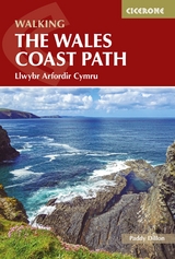
A guidebook to walking the Wales Coast Path (Llwybr Arfordir Cymru) between Chester and Chepstow. Covering 1398km (869 miles), this long-distance trek passing through two national parks, Snowdonia (Eryri) and the Pembrokeshire Coast, takes around 2–3 months to hike.
The route is described from north to south in 57 stages between 16 and 30km (10–19 miles) in length. The stages are presented in 9 sections so the route can be easily broken down into shorter sections or day walks.
1:100,000 maps included for each stage
GPX files available to download
Handy facilities table helps you plan your itinerary
Detailed information on public transport, refreshments and accommodation for each stage
Advice on planning and preparation
Paddy Dillon is a prolific walker and guidebook writer, with 100 guidebooks to his name and contributions to 40 other titles. He has written for several outdoor magazines and other publications and has appeared on radio and television.
Overview map
Route map key
INTRODUCTION
Geology
Brief history of Wales
Scenery
Wildlife
Trees and flowers
Nature reserves
Transport to and from the route
Transport along the route
When to walk
Accommodation
Food and drink
Money matters
Communications
Planning your schedule
Time and tide wait for no man!
What to pack
Waymarking and access
Maps of the route
Emergencies
Using this guide
1 NORTH WALES
Stage 1 Chester to Flint
Stage 2 Flint to Prestatyn
Stage 3 Prestatyn to Colwyn Bay
Stage 4 Colwyn Bay to Conwy
Stage 5 Conwy to Bangor
2 ISLE OF ANGLESEY
Stage 6 Bangor to Glan-yr-afon
Stage 7 Glan-yr-afon to City Dulas
Stage 8 City Dulas to Cemaes
Stage 9 Cemaes to Llanfachraeth
Stage 10 Llanfachraeth to South Stack
Stage 11 South Stack to Fourmilebridge
Stage 12 Fourmilebridge to Aberffraw
Stage 13 Aberffraw to Dwyran
Stage 14 Dwyran to Menai Bridge
3 LL?N PENINSULA
Stage 15 Menai Bridge to Dinas Dinlle
Stage 16 Dinas Dinlle to Nefyn
Stage 17 Nefyn to Methlem
Stage 18 Methlem to Rhiw
Stage 19 Rhiw to Abersoch
Stage 20 Abersoch to Llanystumdwy
Stage 21 Llanystumdwy to Penrhyndeudraeth
4 MEIRIONNYDD
Stage 22 Penrhyndeudraeth to Llandanwg
Stage 23 Llandanwg to Barmouth
Stage 24 Barmouth to Tywyn
Stage 25 Tywyn to Machynlleth
5 CEREDIGION
Stage 26 Machynlleth to Borth
Stage 27 Borth to Llanrhystud
Stage 28 Llanrhystud to New Quay
Stage 29 New Quay to Aberporth
Stage 30 Aberporth to St Dogmaels
6 PEMBROKESHIRE
Stage 31 St Dogmaels to Newport
Stage 32 Newport to Goodwick
Stage 33 Goodwick to Abercastle
Stage 34 Abercastle to St Justinian
Stage 35 St Justinian to Newgale
Stage 36 Newgale to Martin's Haven
Stage 37 Martin's Haven to Sandy Haven
Stage 38 Sandy Haven to Pembroke
Stage 39 Pembroke to Freshwater West
Stage 40 Freshwater West to Freshwater East
Stage 41 Freshwater East to Saundersfoot
7 CARMARTHENSHIRE
Stage 42 Saundersfoot to Laugharne
Stage 43 Laugharne to Llansteffan
Stage 44 Llansteffan to Ferryside
Stage 45 Ferryside to Burry Port
8 THE GOWER
Stage 46 Burry Port to Pen-clawdd
Stage 47 Pen-clawdd to Rhossili
Stage 48 Rhossili to Penmaen
Stage 49 Penmaen to Swansea
9 SOUTH WALES
Stage 50 Swansea to Margam
Stage 51 Margam to Ogmore
Stage 52 Ogmore to Limpert Bay
Stage 53 Limpert Bay to Cadoxton
Stage 54 Cadoxton to Pengam Green
Stage 55 Pengam Green to Newport
Stage 56 Newport to Rogiet
Stage 57 Rogiet to Chepstow
APPENDICES
Appendix A Route summary table
Appendix B Facilities along the route
Appendix C Topographical glossary
Appendix D Useful contacts
| Erscheinungsdatum | 28.04.2022 |
|---|---|
| Reihe/Serie | Cicerone guidebooks |
| Verlagsort | Kendal |
| Sprache | englisch |
| Maße | 116 x 172 mm |
| Gewicht | 420 g |
| Themenwelt | Sachbuch/Ratgeber ► Sport |
| Reisen ► Sport- / Aktivreisen ► Europa | |
| ISBN-10 | 1-78631-066-X / 178631066X |
| ISBN-13 | 978-1-78631-066-8 / 9781786310668 |
| Zustand | Neuware |
| Haben Sie eine Frage zum Produkt? |
aus dem Bereich