Alta Via 2 - Trekking in the Dolomites
Cicerone Press (Verlag)
978-1-78631-097-2 (ISBN)
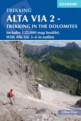
A guidebook to walking the Alta Via 2 (AV2) between Bressanone and Feltre. Covering 174km (108 miles), this long-distance trail through the western Dolomites in northeastern Italy takes about 2 weeks and is suitable for experienced trekkers with a good level of fitness.
The route is described from north to south in 13 stages, each between 8 and 22km (5–14 miles) in length. Overview maps and route descriptions for Alta Via 3, 4, 5 and 6, four harder and more remote north–south routes in the central and eastern Dolomites, are also included. Advice on 3- or 6-day sections of the route for walkers who prefer not to walk AV2 in its entirety is also given.
Includes a separate map booklet containing 1:25,000 Kompass mapping and route line
1:75,000 maps included in the main book for each stage
GPX files available to download
Detailed information about mountain huts and facilities along the route
Advice on planning and preparation
Gillian Price has trekked throughout Asia and the Himalayas, but now lives in Venice. Gillian has steadily explored the mountain ranges of Italy, and Corsica, and brought them to life for visitors in a series of outstanding guides for Cicerone. She is an active member of the Italian Alpine Club (CAI) and Mountain Wilderness.
Map key
Overview map
Route summary table - Alta Via 2
Preface to this edition
Introduction
The Dolomites
Alta Via 2
Alte Vie 3-6
Geology
Languages and place names
Plants and flowers
Wildlife
How to get there
When to go
Shorter itineraries
Accommodation
Food and drink
What to take
Maps and waymarking
Dos and don'ts
Emergencies
Using this guide
Alta Via 2
Stage 1 Bressanone to Rifugio Plose
Stage 2 Rifugio Plose to Rifugio Genova
Stage 3 Rifugio Genova to Rifugio Puez
Stage 4 Rifugio Puez to Rifugio Pisciadù
Stage 5 Rifugio Pisciadù to Rifugio Castiglioni
Stage 6 Rifugio Castiglioni to Passo San Pellegrino
Stage 7 Passo San Pellegrino to Rifugio Mulaz
Stage 8 Rifugio Mulaz to Rifugio Rosetta
Stage 9 Rifugio Rosetta to Rifugio Treviso
Stage 10 Rifugio Treviso to Passo Cereda
Stage 11 Passo Cereda to Rifugio Boz
Stage 12 Rifugio Boz to Rifugio Dal Piaz
Stage 13 Rifugio Dal Piaz to Feltre
Alte Vie 3-6
Alta Via 3
Alta Via 4
Alta Via 5
Alta Via 6
Appendix A Useful contacts
Appendix B Italian-English glossary
| Erscheinungsdatum | 06.06.2022 |
|---|---|
| Reihe/Serie | Cicerone guidebooks |
| Verlagsort | Kendal |
| Sprache | englisch |
| Maße | 116 x 172 mm |
| Gewicht | 230 g |
| Themenwelt | Sachbuch/Ratgeber ► Sport |
| Reisen ► Sport- / Aktivreisen ► Europa | |
| ISBN-10 | 1-78631-097-X / 178631097X |
| ISBN-13 | 978-1-78631-097-2 / 9781786310972 |
| Zustand | Neuware |
| Haben Sie eine Frage zum Produkt? |
aus dem Bereich