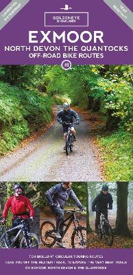
Exmoor, North Devon & the Quantocks Off-Road Bike Routes Map
Goldeneye (Verlag)
978-1-85965-285-5 (ISBN)
Explore Exmoor and North Devon on your mountain bike with this laminated, waterproof Exmoor map. With 10 clearly-marked routes this easy-to-use map will help you discover the best of Exmoor and North Devon off road.
From sand-dunes, surf beaches and rocky cliffs of the coast, through wooded hills and green-pastured valleys to the heather and tawny-grasses of the high moors; for such a small area Exmoor contains an extraordinary variety of scenery. Add the pubs and cafes of friendly country towns, and the fabled Devon cream teas of village tea-shops, all linked by narrow, high-banked lanes which see little traffic that much of their surface is covered by moss and grass, and a network of forest tracks and ancient green lanes and bridleways, and you have one of the secret jewels of the UK's off-road riding scene.
But what you won't get - with one or two very obvious exceptions - are bone-juddering gnarly descents, so if you're looking for the "Oh my God" factor, this isn't the place. Instead, you have a collection of superbly varied and rideable routes - from the almost flat circuit of Braunton and the Burrows to the challenging climbs and long, open descents of some of the inland routes.
Outside of Exmoor's National Park, the Quantock Hills deserve a special mention. With views out over the waters of the Bristol Channel, this area of interconnected ridges above steeply wooded combes is covered with trails that could have been designated for off-road biking. But when the sun is shining on the great ridge of the Quantocks from Crowcombe Park Gate towards Beacon Hill, or high up on Dunkery Beacon in the midst of Exmoor - one thing is for sure - this is as close to off-road riding heaven as it gets.
Al Churcher is an Olympic Triathlete with over 43 years world-wide experience in a wide range of adventurous outdoor activities; from climbing, road cycling and mountain biking, hiking, fell running, swimming, downhill skiing and ski mountaineering. He is the author of Classic Climbs in the Dolomites (Cicerone Press 1987), Italian Rock - Selected Climbs in Northern Italy (Cicerone Press 1988), Great Routes in the Cotswolds - Mountain Bike Maps (Goldeneye 1998), Great Routes in the Peak District - Mountain Bike Maps (Goldeneye 1998), Dartmoor Mountain Bike Routes (Goldeneye 2005), and, Exmoor North Devon The Quantocks Mountain Bike Routes (Goldeneye 2004). Al has devised cycle routes for the Goldeneye range of Cycling Country Lanes & Byways to:- Dorset, Dartmoor & South Devon, Exmoor & North Devon, Lake District, North York Moors, Peak District, Pembrokeshire, Snowdonia, Suffolk and the Yorkshire Dales. He regularly contributes articles and photographs to a wide range of outdoor magazines.
| Erscheint lt. Verlag | 1.5.2023 |
|---|---|
| Reihe/Serie | Goldeneye Cycling Guides |
| Verlagsort | Cheltenham |
| Sprache | englisch |
| Maße | 125 x 245 mm |
| Themenwelt | Sachbuch/Ratgeber ► Sport ► Motor- / Rad- / Flugsport |
| Reisen ► Karten / Stadtpläne / Atlanten ► Europa | |
| Reisen ► Reiseführer | |
| ISBN-10 | 1-85965-285-9 / 1859652859 |
| ISBN-13 | 978-1-85965-285-5 / 9781859652855 |
| Zustand | Neuware |
| Haben Sie eine Frage zum Produkt? |
aus dem Bereich
![Uckermark, 1:75.000 [offizielle Karte des ADFC, Allgemeiner Deutscher Fahrrad-Club] - ADFC - Allgemeiner Deutscher Fahrrad-Club e.V.](/media/107442469)

