Trekking the GR20 Corsica
Cicerone Press (Verlag)
978-1-78631-067-5 (ISBN)
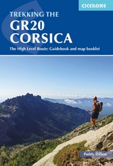
A guidebook to trekking the GR20 Corsica, widely considered to be the most difficult of Europe’s GR long-distance routes. The 190km (118 mile) trail from Calinzana to Conca traverses the island’s mountainous heart and calls for both fitness and experience. Crossing remote and rugged mountainous terrain, there is plenty of hands-on scrambling and, although it is possible to stay under a roof every night, it is recommended that trekkers carry backpacking kit.
The GR20 is presented in 16 stages of 5 to 18km (3–11 miles), with low-level options provided for a number of the stages. It takes around a fortnight to complete. Also included are a handful of excursions to climb neighbouring peaks and link routes for those wishing to join or leave the trail.
Clear route description with 1:50,000 maps and elevation profiles
Includes separate map booklet featuring 1:25,000 IGN mapping
GPX files available for download
Route summary and facilities summary tables help you plan your itinerary
With accommodation listings
Paddy Dillon is a prolific walker and guidebook writer, with 100 guidebooks to his name and contributions to 40 other titles. He has written for several outdoor magazines and other publications and has appeared on radio and television. Paddy uses a tablet computer to write as he walks. His descriptions are therefore precise, having been written at the very point at which the reader uses them. Paddy is an indefatigable long-distance walker who has walked all of Britain's National Trails and several trails in Europe and further afield.
Map key
Overview map
Route summary table
Introduction
Geology
Brief history
Getting to Corsica
Getting around Corsica
Getting to the GR20
When to trek
How to trek
Maps
Mountain weather
Path conditions
Mountain rescue
What to take
Services along the route
Food, drink and fuel
Language
Currency
Using this guide
Plants and wildlife on Corsica
Maquis
Trees
Flowers
Wildlife
The GR20
Stage 1A Calinzana to Refuge d'Ortu di u Piobbu (high-level)
Stage 1B Calinzana to Refuge d'Ortu di u Piobbu (low-level)
Excursion Ascent of Monte Corona from Refuge d'Ortu di u Piobbu
Stage 2A Refuge d'Ortu di u Piobbu to Refuge de Carozzu (high-level)
Stage 2B Refuge d'Ortu di u Piobbu to Refuge de Carozzu (low-level)
Stage 3 Refuge de Carozzu to Ascu Stagnu
Stage 4 Ascu Stagnu to Auberge U Vallone
Link route Auberge U Vallone to Albertacce
Stage 5 Auberge U Vallone to Hôtel Castel di Vergio
Excursion Ascent of Paglia Orba from Refuge de Ciotullu di I Mori
Stage 6 Hôtel Castel di Vergio to Refuge de Manganu
Link route Bergerie de Vaccaghja to Corti
Link route Refuge de Manganu to Soccia
Stage 7 Refuge de Manganu to Refuge de Petra Piana
Link route Br&##xe8;che de Capitellu or Bocca a Soglia to Bergeries de Grottelle
Excursion Ascent of Monte Ritondu from Refuge de Petra Piana
Stage 8A Refuge de Petra Piana to Refuge de l'Onda (low-level)
Stage 8B Refuge de Petra Piana to Refuge de l'Onda (high-level)
Link route Bergerie de Tolla to Tattone and Vizzavona
Stage 9A Refuge de l'Onda to Vizzavona (low-level)
Stage 9B Refuge de l'Onda to Vizzavona (high-level)
Stage 10 Vizzavona to Bergeries d'E Capanelle
Link route La Foce to Bocca Palmentu
Stage 11A Bergeries d'E Capanelle to Bocca di Verdi (low-level)
Stage 11B Bergeries d'E Capanelle to Bocca di Verdi (high-level)
Stage 12 Bocca di Verdi to Refuge d'Usciolu
Link route Refuge d'Usciolu to Cuzz&##xe0;
Stage 13 Refuge d'Usciolu to Refuge de Matalza
Link route Tignosellu to Zicavu
Link route Zicavu to Refuge de Matalza
Stage 14 Refuge de Matalza to Refuge d'Asinau
Alt Stage 13/14 Refuge d'Usciolu to Refuge d'Asinau (variant)
Stage 15A Refuge d'Asinau to Bavedda (low-level)
Stage 15B Refuge d'Asinau to Bavedda (high-level)
Stage 16 Bavedda to Conca
Appendix A Facilities along the route (Calinzana to Conca)
Appendix B Facilities along the route (Conca to Calinzana)
Appendix C Accommodation list
Appendix D Basic language notes
Appendix E Useful contacts
Appendix F The Cirque de la Solitude
| Erscheinungsdatum | 06.06.2022 |
|---|---|
| Reihe/Serie | Cicerone guidebooks |
| Verlagsort | Kendal |
| Sprache | englisch |
| Maße | 116 x 172 mm |
| Gewicht | 430 g |
| Themenwelt | Sachbuch/Ratgeber ► Sport |
| Reisen ► Sport- / Aktivreisen ► Europa | |
| ISBN-10 | 1-78631-067-8 / 1786310678 |
| ISBN-13 | 978-1-78631-067-5 / 9781786310675 |
| Zustand | Neuware |
| Haben Sie eine Frage zum Produkt? |
aus dem Bereich