Trekking the GR7 in Andalucia
Cicerone Press (Verlag)
978-1-85284-995-5 (ISBN)
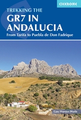
The GR7 is one of Europe's longest GR long-distance routes, stretching from Tarifa, the southernmost town of continental Europe, through Spain, Andorra and France to Alsace. This guide presents the Andalucian section of the route, which offers well over 700km of fantastic walking through the diverse landscapes of one of Spain's most evocative regions. The route splits at the small village of Villanueva de Cauche, and the guide describes both the northern and southern variants. Although walking is on good footpaths, country tracks and, occasionally, minor roads, some of the stages are long and can involve considerable ascent, meaning that a good level of fitness is required. The full Andalucian GR7 takes well over a month to walk; however, the guide also includes suggestions for highlight sections that can be walked in a week or fortnight.
In addition to clear route description, mapping and elevation profiles, the guide provides background information on local history, plants and wildlife, and advice for planning your trip, such as when to go, what to take and where to stay.
The route showcases Andalucia's rich history and culture and varied landscapes, which include pine forests, semi-arid desert, snow-capped peaks, fertile plains, lush valleys, olive groves, cultivated terraces and hills of cork woodland. Historic towns and traditional whitewashed villages offer overnight accommodation and a chance to sample local cuisine.
Guy Hunter-Watts has lived and worked in Andalucia since the 1980s. After studying at the universities of Santiago and Salamanca, he taught English in South America before moving to the Ronda mountains where he has been leading guided walks for almost 30 years. His work as a walking guide and freelance journalist has taken him to many corners of the planet including India, Namibia, Tanzania, Latin America and Mongolia.
Map key
Overview map
Route summary table
Author's preface
Introduction
The GR7/E4
Andalucia
The GR7 in Andalucia
Shorter itineraries
Historical context
Plants and wildlife
When to go
Getting there
Getting back
Luggage transfer
Accommodation
Food and drink
Water
Equipment
Money
Language
Waymarking
Maps and GPS
Staying safe
Using this guide
The common route
Cadiz province
Stage 1 Tarifa to Los Barrios
Stage 2 Los Barrios to Castillo de Castellar
Stage 3 Castillo de Castellar to Jimena de la Frontera
Stage 4 Jimena de la Frontera to Ubrique
Stage 5 Ubrique to Montejaque via Villaluenga del Rosario
Malaga province
Stage 6 Montejaque to Arriate via Ronda
Stage 7 Arriate to Ardales
Stage 8 Ardales to El Chorro
Stage 9 El Chorro to Valle de Abdalajis
Stage 10 Valle de Abdalajis to Antequera
Stage 11 Antequera to Villanueva de Cauche
The northern variant
Stage 12A Villanueva de Cauche to Villanueva del Trabuco
Stage 13A Villanueva del Trabuco to Villanueva de Tapia
Stage 14A Villanueva de Tapia to Villanueva de Algaidas
Stage 15A Villanueva de Algaidas to Cuevas de San Marcos
Cordoba province
Stage 16A Cuevas de San Marco to Rute
Stage 17A Rute to Priego de Cordoba
Stage 18A Priego de Cordoba to Almedinilla
Stage 19A Almedinilla to Alcala La Real
Jaen province
Stage 20A Alcala la Real to Frailes
Stage 21A Frailes to Carchelejo
Stage 22A Carchelejo to Cambil
Stage 23A Cambil to Torres
Stage 24A Torres to Bedmar
Stage 25A Bedmar to Jodar
Stage 26A Jodar to Quesada
Stage 27A Quesada to Cazorla
Stage 28A Cazorla to Vadillo Castril
Stage 29A Vadillo Castril to Coto Rios
Stage 30A Coto Rios to Pontones
Stage 31A Pontones to Santiago de la Espada
Stage 32A Santiago de la Espada to Puebla de Don Fadrique
The southern variant
Stage 12B Villanueva de Cauche to Riogordo
Stage 13B Riogordo to Ventas de Zafarraya
Granada province
Stage 14B Ventas de Zafarraya to Alhama de Granada
Stage 15B Alhama de Granada to Arenas del Rey
Stage 16B Arenas del Rey to Jayena
Stage 17B Jayena to Albunuelas
Stage 18B Albunuelas to Niguelas
Stage 19B Niguelas to Lanjaron
Stage 20B Lanjaron to Soportujar
Stage 21B Soportujar to Pitres
Stage 22B Pitres to Trevelez
Stage 23B Trevelez to Cadiar
Stage 24B Cadiar to Yegen
Stage 25B Yegen to Laroles
Stage 26B Laroles to Puerto de la Ragua via Bayarcal
Stage 27B Puerto de la Ragua to La Calahorra
Stage 28B La Calahorra to Narvaez via Charches
Stage 29B Narvaez to Zujar
Stage 30B Zujar to Benamaurel
Stage 31B Benamaurel to Cullar
Stage 32B Cullar to Orce
Stage 33B Orce to Huescar
Stage 34B Huescar to Puebla de Don Fadrique
Appendix A Facilities table
Appendix B Spanish-English glossary
Appendix C Further information
Appendix D Further reading
| Erscheinungsdatum | 05.10.2021 |
|---|---|
| Reihe/Serie | Cicerone guidebooks |
| Zusatzinfo | 56 maps, 55 elevation profiles and over 90 colour photos |
| Verlagsort | Kendal |
| Sprache | englisch |
| Maße | 116 x 172 mm |
| Themenwelt | Sachbuch/Ratgeber ► Sport |
| Reisen ► Sport- / Aktivreisen ► Europa | |
| ISBN-10 | 1-85284-995-9 / 1852849959 |
| ISBN-13 | 978-1-85284-995-5 / 9781852849955 |
| Zustand | Neuware |
| Haben Sie eine Frage zum Produkt? |
aus dem Bereich