Trekking the Cathar Way
Cicerone Press (Verlag)
978-1-78631-047-7 (ISBN)
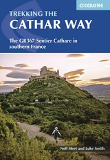
A guidebook to trekking the GR367 Cathar Way (Sentier Cathare) between Port-la-Nouvelle on the Mediterranean coast and Foix in the foothills of the Pyrenees. Covering 260km (162 miles), this long-distance trek through the Languedoc region of southern France takes around 2 weeks to hike and is suitable for hikers with some experience.
The route is described from east to west in 13 stages, each between 12 and 27km (7–17 miles in length). A shorter northern variant is included that explores remoter areas of the Languedoc.
1:100,000 maps included for each stage
GPX files available to download
Detailed information about accommodation and facilities along the route
The route links several Cathar castles and provides insight into Cathar history
Luke and Nell are hikers, travellers and bloggers who detail their slow-travel adventures around the world on their blog whatifwewalked.com. Inveterate world backpackers, they started the blog in 2017 when they walked the 2000km Via Francigena from Canterbury to Rome. Since then they have walked extensively in Europe photographing, writing and blogging about trails in Germany, Spain, Portugal, the Faroe Islands, Scotland and beyond. This is their first guidebook for Cicerone.
Map key
Overview map
Route summary table
Introduction
Languedoc history
The Cathars and the Crusade
The Cathar Way route
Features of interest
Planning the walk
North variant
Alternative ways to stage the Cathar Way
Getting there
Getting around
When to go
Accommodation
Food and drink
Language
Money matters
Phone and Wi-Fi
Health and safety
What to take
Maps
Waymarking
Updates
Using this guide
The Cathar Way
Port-la-Nouvelle to Puivert
Stage 1 Port-la-Nouvelle to Durban-Corbi&##xe8;res
Stage 2 Durban-Corbi&##xe8;res to Tuchan
Stage 3 Tuchan to Cucugnan
Stage 4 Cucugnan to Saint-Paul-de-Fenouillet
Stage 5 Saint-Paul-de-Fenouillet to Caudi&##xe8;s-de-Fenouill&##xe8;des
Stage 6 Caudi&##xe8;s-de-Fenouill&##xe8;des to Axat
Stage 7 Axat to Quirbajou
Stage 8 Quirbajou to Puivert
Cucugnan to Puivert: north variant
Stage 4a Cucugnan to Camps-sur-l'Agly
Stage 5a Camps-sur-l'Agly to Bugarach
Stage 6a Bugarach to Quillan
Stage 7a Quillan to Puivert
Puivert to Foix
Stage 9 Puivert to Espezel
Stage 10 Espezel to Comus
Stage 11 Comus to Monts&##xe9;gur
Stage 12 Monts&##xe9;gur to Roquefixade
Stage 13 Roquefixade to Foix
Appendix A Villages and towns with amenities
Appendix B Accommodation
Appendix C Useful contacts
Appendix D French-English glossary
Appendix E Further information and reading
| Erscheinungsdatum | 28.01.2022 |
|---|---|
| Reihe/Serie | Cicerone guidebooks |
| Verlagsort | Kendal |
| Sprache | englisch |
| Maße | 116 x 172 mm |
| Gewicht | 210 g |
| Themenwelt | Sachbuch/Ratgeber ► Sport |
| Reisen ► Sport- / Aktivreisen ► Europa | |
| ISBN-10 | 1-78631-047-3 / 1786310473 |
| ISBN-13 | 978-1-78631-047-7 / 9781786310477 |
| Zustand | Neuware |
| Haben Sie eine Frage zum Produkt? |
aus dem Bereich