


Road Map Ireland
2020
Automobile Association (Verlag)
978-0-7495-8231-9 (ISBN)
Automobile Association (Verlag)
978-0-7495-8231-9 (ISBN)
- Titel ist leider vergriffen;
keine Neuauflage - Artikel merken
Zu diesem Artikel existiert eine Nachauflage
New edition, fully updated.
Super-clear mapping of the whole of Ireland.
Durable encapsulated paper cover.
Detailed road network and easy-to-read place names.
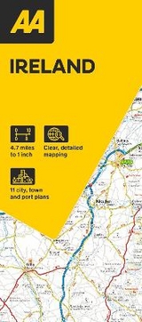
This folded, double-sided sheet map shows the detailed road network with toll motorways and dual carriageways clearly identifi ed. As well as presenting an array of places of interest for tourists and locals alike, the mapping includes motorway service areas, AA-inspected campsites, viewpoints and picnic sites. Gaeltacht regions are highlighted with place names shown in both English and Irish. The map includes 6 city plans of Dublin, Belfast, Cork, Derry Londonderry, Sligo and Waterford and 5 port plans. Additionally, a separate map of Ireland features relief shading with key physical landmarks.
Super-clear mapping of the whole of Ireland.
Durable encapsulated paper cover.
Detailed road network and easy-to-read place names.
This folded, double-sided sheet map shows the detailed road network with toll motorways and dual carriageways clearly identifi ed. As well as presenting an array of places of interest for tourists and locals alike, the mapping includes motorway service areas, AA-inspected campsites, viewpoints and picnic sites. Gaeltacht regions are highlighted with place names shown in both English and Irish. The map includes 6 city plans of Dublin, Belfast, Cork, Derry Londonderry, Sligo and Waterford and 5 port plans. Additionally, a separate map of Ireland features relief shading with key physical landmarks.
AA Publishing is the UK's largest travel publisher.
| Erscheint lt. Verlag | 2.4.2020 |
|---|---|
| Verlagsort | Basingstoke |
| Sprache | englisch |
| Maße | 110 x 246 mm |
| Themenwelt | Reisen ► Karten / Stadtpläne / Atlanten ► Europa |
| ISBN-10 | 0-7495-8231-6 / 0749582316 |
| ISBN-13 | 978-0-7495-8231-9 / 9780749582319 |
| Zustand | Neuware |
| Haben Sie eine Frage zum Produkt? |
Mehr entdecken
aus dem Bereich


aus dem Bereich
Straßen- und Freizeitkarte 1:250.000
Karte (gefalzt) (2023)
Freytag-Berndt und ARTARIA (Verlag)
12,90 €
Karte (gefalzt) (2023)
Freytag-Berndt und ARTARIA (Verlag)
12,90 €
Östersund
Karte (gefalzt) (2023)
Freytag-Berndt und ARTARIA (Verlag)
12,90 €