Walking the Shropshire Way
Cicerone Press (Verlag)
978-1-78631-008-8 (ISBN)
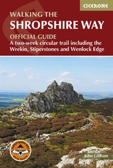
A guidebook to walking the Shropshire Way. Covering 290km (182 miles), this long-distance circular trek exploring the area around Shrewsbury can be hiked in around 2 weeks and is suitable for all reasonably fit walkers.
The route is described in 15 stages, each between 18 and 24km (11–15 miles) in length, and comprises two loops that can each be walked separately in a week or combined to form a 2-week trek. The challenging 2-day Stretton Skyline Walk (32km, 20 miles) is also included.
1:50,000 OS maps included for each stage
GPX files available to download
Detailed information on facilities, public transport and accommodation on route
Advice on planning and preparation
Highlights include Stiperstones and Wenlock Edge
John Gillham has been a professional writer, illustrator and photographer since 1989. His first book was Snowdonia to the Gower: a Coast-to-Coast Walk Across Highest Wales. He also pioneered three other long-distance routes: Lakeland to Lindisfarne, Pennine Ways and the Bowland-Dales Traverse, all of which were published in book form. John writes for several outdoor publications, and two of his books have won the Outdoor Writers & Photographers Guild Award for Excellence.
Overview map
Overview profile
Map key
Foreword
Route summary table
Introduction
The Shropshire Way
Shropshire's history
Shropshire's geology (by Ronald Turnbull)
Wildlife and plants
When to go
Getting there
Getting around
Accommodation and planning
Safety
What to take
Using GPS
Waymarking
Using this guide
The Shropshire Way
Stage 1 Shrewsbury to Bridges
Stage 2 Bridges to Bishop's Castle
Stage 3 Bishop's Castle to Clun
Stage 4 Clun to Craven Arms
Stage 5 Craven Arms to Ludlow
Stage 6 Ludlow to Wheathill
Stage 7 Wheathill to Wilderhope Manor
Stage 8 Wilderhope to Ironbridge
Stage 9 Ironbridge to Wellington
Stage 10 Wellington to Haughmond
Stage 10A Haughmond to Shrewsbury link
Stage 11 Haughmond to Wem
Stage 12 Wem to Ellesmere and Whitchurch
Stage 13 Ellesmere to Llanymynech
Stage 14 Llanymynech to Nesscliffe
Stage 15 Nesscliffe to Shrewsbury
Stretton Skyline Walk
Appendix A Facilities table
Appendix B Accommodation
Appendix C Travel information
Appendix D Useful contacts
| Erscheinungsdatum | 29.10.2019 |
|---|---|
| Reihe/Serie | Cicerone guidebooks |
| Zusatzinfo | 61 colour photos, 17 OS 1:50,000 colour maps |
| Verlagsort | Kendal |
| Sprache | englisch |
| Maße | 116 x 172 mm |
| Gewicht | 220 g |
| Themenwelt | Sachbuch/Ratgeber ► Sport |
| Reisen ► Sport- / Aktivreisen ► Europa | |
| ISBN-10 | 1-78631-008-2 / 1786310082 |
| ISBN-13 | 978-1-78631-008-8 / 9781786310088 |
| Zustand | Neuware |
| Haben Sie eine Frage zum Produkt? |
aus dem Bereich