Walking the Galloway Hills
Cicerone Press (Verlag)
978-1-78631-010-1 (ISBN)
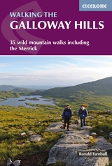
A guidebook to 34 day walks and one long-distance route in the wild and remote hills of Galloway. Although there are some shorter and easier routes, many of these hill walks are long and on rugged terrain, so are more suitable for experienced walkers.
The day walks range from 4-33km (2-20 miles) and can be enjoyed in 2-11 hours, with options to combine routes to form longer days. A 3-day trek covering 82km (53 miles) is also detailed.
1:50,000 OS maps included for each walk
GPX files available to download
Easy access from Newton Stewart, Glentrool village, Loch Trool, Dalmellington, Carsphairn and St John's Town of Dalry
Detailed information on planning, bothies and the history of the area
Sized to easily fit in a jacket pocket
Ronald Turnbull writes regularly for TGO, Lakeland Walker, Trail and Cumbria magazines. His previous books include Across Scotland on Foot, Long Days in Lakeland and Welsh 3000ft Challenges. He has written many other Cicerone guides, including Walking in the Lowther Hills, The Book of the Bivvy and Not the West Highland Way. He has lived in Dumfries and Galloway for the last 40 years.
Map key Overview map Introduction Harshness and heather Geology of the Galloway Hills Wildlife and wet Free Forest of Buchan Forest park and biosphere Climbing and scrambling When to walk Getting here, getting around, staying the night Maps and GPS Safety in the hills Using this book Section 1: Glen Trool Route 1 Water of Minnoch and Glen Trool Route 2 Water of Trool Route 3 Around Loch Trool Route 4 Fell of Eschoncan to Bennan Route 5 Merrick and Rig of the Buchan Route 6 The Three Lochs Route 7 Craignaw Route 8 Craiglee and Rig of the Jarkness Route 9 Mulldonoch to Curleywee Route 10 Caldron of the Merrick Section 2: The Awful Hand Route 11 Kirriereoch Hill and Merrick Route 12 The Awful Hand: Shalloch to Benyellary Route 13 Shalloch on Minnoch Route 14 Craigmasheenie and Shiel Hill Section 3: Loch Doon Route 15 Craiglee of Doon Route 16 Hoodens Hill and Mullwharchar Route 17 Northern Rhinns of Kells from Loch Doon Section 4: The Glenkens Route 18 Garryhorn and the northern Rhinns of Kells Route 19 Cairnsmore of Carsphairn Route 20 Craig of Knockgray Route 21 Corserine from Forrest Lodge Route 22 Southern Rhinns of Kells Route 23 Mulloch Hill Route 24 Waterside Hill Route 25 Dunveoch Section 5: Talnotry and the south Route 26 Larg Hill to Curleywee Route 27 Curleywee by Stronbae Hill Route 28 Millfore Route 29 Cairnsmore of Fleet from the north Route 30 Cairnsmore of Fleet from the south Route 31 Clints of Dromore Route 32 Knockman Wood Route 33 The Thieves Stones Route 34 Wood of Cree Section 6: Expeditions Route 35 Not the Southern Upland Way Other routes Appendix A Route summary table Appendix B The bothies Appendix C Information points
| Erscheinungsdatum | 20.07.2019 |
|---|---|
| Reihe/Serie | Cicerone guidebooks |
| Verlagsort | Kendal |
| Sprache | englisch |
| Maße | 116 x 172 mm |
| Gewicht | 230 g |
| Themenwelt | Sachbuch/Ratgeber ► Sport |
| Reisen ► Sport- / Aktivreisen ► Europa | |
| ISBN-10 | 1-78631-010-4 / 1786310104 |
| ISBN-13 | 978-1-78631-010-1 / 9781786310101 |
| Zustand | Neuware |
| Haben Sie eine Frage zum Produkt? |
aus dem Bereich