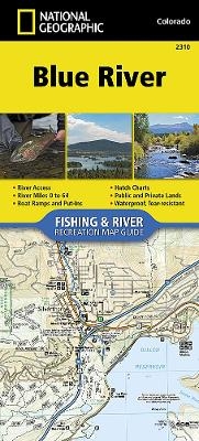
Blue River Map
Seiten
2018
|
2023rd ed.
National Geographic Maps (Verlag)
978-1-56695-766-3 (ISBN)
National Geographic Maps (Verlag)
978-1-56695-766-3 (ISBN)
- Keine Verlagsinformationen verfügbar
- Artikel merken
Waterproof, Tear-Resistant Fishing & River Map. The Blue River Fishing & River Map Guide is designed to be the perfect companion to anyone recreating on this picturesque river. Beginning as a small trickle from its perch high on the Divide at Hoosier Pass, the Blue River descends approximately 65 miles to reach its confluence with the Colorado River near Kremmling. Dropping over 4,000 feet in elevation, the river winds through diverse landscapes and passes through the towns of Blue River, Breckenridge, Dillon, and Silverthorne. A variety of ecosystems are supported as it morphs into a medium-size waterway known for prolific insect life, oversize rainbow trout, and the wild and scenic landscape-punctuated by snowcapped peaks, rugged canyons, and pine-lined banks-through which it passes. Offering copious chances for recreation - including kayaking, white water rafting, canoeing, stand-up paddleboarding, and stellar angling - this waterway, and its tributaries - which are the lifeblood o
| Erscheint lt. Verlag | 24.8.2018 |
|---|---|
| Zusatzinfo | 1 Illustrations, unspecified |
| Verlagsort | Evergreen |
| Sprache | englisch |
| Maße | 115 x 245 mm |
| Themenwelt | Reisen ► Karten / Stadtpläne / Atlanten ► Nord- / Mittelamerika |
| Reiseführer ► Nord- / Mittelamerika ► USA | |
| ISBN-10 | 1-56695-766-4 / 1566957664 |
| ISBN-13 | 978-1-56695-766-3 / 9781566957663 |
| Zustand | Neuware |
| Haben Sie eine Frage zum Produkt? |
Mehr entdecken
aus dem Bereich
aus dem Bereich
Karte (gefalzt) (2024)
Michelin Editions des Voyages (Verlag)
11,95 €
Map
Karte (gefalzt) (2024)
Michelin Editions des Voyages (Verlag)
19,95 €


