The Pyrenean Haute Route
Cicerone Press (Verlag)
978-1-85284-981-8 (ISBN)
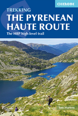
A guidebook to trekking the 748km (465 mile) Pyrenean Haute Route (Haute Randonnée Pyrénéenne, HRP) along the France–Spain border. Suitable for fit experienced trekkers comfortable with mountainous terrain, this challenging unwaymarked route traverses the Pyrenees from sea to sea, from Hendaye on the Atlantic Coast to Banyuls-sur-Mer on the Mediterranean, with the aim of staying as high as possible.
The PHR is divided into 44 graded stages of 8 to 28km (5–17 miles), nearly all ending at overnight accommodation. These are presented in 5 sections, which can be accessed by public transport, for the benefit of those wishing to trek only part of the route. Also included are optional ascents of 10 classic summits, including Vignemale, Le Taillon and Pico de Aneto.
1:100,000 mapping and elevation profile provided for each stage
GPX files available for download
Handy route summary and facilities tables help you plan your itinerary
Accommodation and facilities
Advice on planning and preparation, including equipment, supplies and safety considerations
Tom Martens grew up in Belgium and first visited the Pyrenees in 2008 with a friend. This first exploration was so enchanting that he has been back every year since. He has hiked extensively in the national parks and has traversed the whole length of the Pyrenees several times. He also enjoys hiking in Scotland and Estonia, where he currently lives.
Preface
Map key
Overview map
Route summary tables
Introduction
The route
Geology
Plants and wildlife
Mountain weather
When to go
Getting there
Accommodation and services
Food, drink and fuel
What to take
Maps
Path conditions
Insurance, mountain safety and rescue
Using this guide
Section 1: Hendaye to Lescun
Day 1 Hendaye to Col de Lizuniaga
Day 2 Col de Lizuniaga to Arizkun
Day 3 Arizkun to Aldudes
Day 4 Aldudes to Roncesvalles
Day 5 Roncesvalles to Egurgui
Day 6 Egurgui to Col Bagargui
Day 7 Col Bagargui to Cabane d'Ardan&##xe9;
Day 8 Cabane d'Ardan&##xe9; to Source de Marmitou
Day 9 Source de Marmitou to Lescun
Variant 1 From Refugi de Belagua to Lescun via La Pierre Saint-Martin
Section 2: Lescun to Gavarnie
Day 10 Lescun to Refuge d'Arlet
Day 11 Refuge d'Arlet to Candanchu
Day 12 Candanchu to Refuge de Pombie
Day 13 Refuge de Pombie to Refuge de Larribet
Day 14 Refuge de Larribet to Refuge Wallon
Variant 2 Refuge d'Arr&##xe9;moulit to Refuge Wallon
Summit 1 Grande Fache (3005m) from Refuge Wallon
Day 15 Refuge Wallon to Refuge de Bayssellance
Summit 2 Vignemale (3298m) from Refuge de Bayssellance
Day 16 Refuge de Bayssellance to Gavarnie
Summit 3 Le Taillon (3144m) from Gavarnie
Section 3: Gavarnie to Salardú
Day 17 Gavarnie to H&##xe9;as
Summit 4 Pim&##xe9;n&##xe9; (2801m) from Refuge des Espuguettes
Day 18 H&##xe9;as to Parz&##xe1;n
Variant 3 Parz&##xe1;n via the high route to Hourquette de H&##xe9;as
Day 19 Parz&##xe1;n to Refugio de Viados
Day 20 Refugio de Viados to Refuge de la Soula
Day 21 Refuge de la Soula to Refuge du Portillon
Day 22 Refuge du Portillon to Refugio de la Renclusa
Summit 5 Pic Perdigu&##xe8;re (3222m) from Portal de Remune
Summit 6 Pico de Aneto (3404m) from Refugio de la Renclusa
Day 23 Refugio de la Renclusa to Hospital de Vielha
Day 24 Hospital de Vielha to Refugi de la Restanca
Day 25 Refugi de la Restanca to Salardú
Summit 7 Montardo d'Aran (2826m) from the Coll de Crestada
Variant 4 Three days on the GR11 from Refugio de Viados to
Hospital de Vielha
Section 4: Salardú to l'Hospitalet-pr&##xe8;s-l'Andorre
Day 26 Salardú to Refugi Gr&##xe0;cia Airoto
Day 27 Refugi Gr&##xe0;cia Airoto to Alós d'Isil
Day 28 Alós d'Isil to Refugi Enric Pujol
Summit 8 Mont Roig (2868m) from Refugi Enric Pujol
Day 29 Refugi Enric Pujol to Refugi de Certascan
Variant 5 To Noarre via Tavascan
Summit 9 Pic de Certascan (2853m) from Coll de Certascan
Day 30 Refugi de Certascan to Refugi de Baborte/del Cinquantenari
Day 31 Refugi de Baborte/del Cinquantenari to Étang de la Soucarrane
Day 32 Étang de la Soucarrane to Refugi de Sorteny
Day 33 Refugi de Sorteny to Refugi de Cabana Sorda
Day 34 Refugi de Cabana Sorda to l'Hospitalet-pr&##xe8;s-l'Andorre
Section 5: L'Hospitalet-pr&##xe8;s-l'Andorre to Banyuls-sur-Mer
Day 35 L'Hospitalet-pr&##xe8;s-l'Andorre to Refuge des B&##xe9;sines
Day 36 Refuge des B&##xe9;sines to Refuge des Bouillouses
Variant 6 GR10 to Refuge des Bouillouses
Day 37 Refuge des Bouillouses to Eyne
Day 38 Eyne to Refugi d'Ull de Ter
Summit 10 Pic des Bastiments (2881m)
Day 39 Refugi d'Ull de Ter to Refuge de Mariailles
Day 40 Refuge de Mariailles to Refuge de Bat&##xe8;re
Variant 7 GR10 to Refuge des Cortalets
Day 41 Refuge de Bat&##xe8;re to Moulin de la Palette
Day 42 Moulin de la Palette to Las Illas
Day 43 Las Illas to Col de l'Ouillat
Day 44 Col de l'Ouillat to Banyuls-sur-Mer
Appendix A Useful contacts
Appendix B Glossary
Appendix C Facilities table
| Erscheinungsdatum | 27.04.2019 |
|---|---|
| Reihe/Serie | Cicerone guidebooks |
| Zusatzinfo | 66 maps, 60 route profiles, over 100 colour photos |
| Verlagsort | Kendal |
| Sprache | englisch |
| Maße | 116 x 172 mm |
| Gewicht | 390 g |
| Themenwelt | Sachbuch/Ratgeber ► Sport |
| Reisen ► Sport- / Aktivreisen ► Europa | |
| ISBN-10 | 1-85284-981-9 / 1852849819 |
| ISBN-13 | 978-1-85284-981-8 / 9781852849818 |
| Zustand | Neuware |
| Haben Sie eine Frage zum Produkt? |
aus dem Bereich