


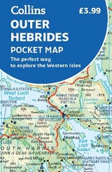
Outer Hebrides Pocket Map
The Perfect Way to Explore the Western Isles
Seiten
2019
Collins (Verlag)
978-0-00-832546-6 (ISBN)
Collins (Verlag)
978-0-00-832546-6 (ISBN)
- Titel erscheint in neuer Auflage
- Artikel merken
Zu diesem Artikel existiert eine Nachauflage
Explore new places with handy pocket maps from Collins.
Handy little full colour map of the Western Isles of Scotland. Detailed mapping and tourist information for the islands of Lewis, Harris, Uist, Benbecula, Barra and St Kilda. Excellent value and very detailed for its size.
Main features of this map include:
• Clear mapping at a scale of 3.2 miles to 1 inch
• Tourist attractions located and described
• Ideal for touring with sights, places to stay, cafe/restaurant, things to do all on the map
• Transport links map showing how to get to and depart the islands
• Index to places of interest and place names
Essential for those planning a trip around the Western Isles.
Explore the world through accurate and up-to-date mapping.
| Erscheint lt. Verlag | 7.2.2019 |
|---|---|
| Zusatzinfo | Index |
| Verlagsort | London |
| Sprache | englisch |
| Maße | 90 x 140 mm |
| Gewicht | 30 g |
| Themenwelt | Reisen ► Karten / Stadtpläne / Atlanten ► Europa |
| Reiseführer ► Europa ► Großbritannien | |
| ISBN-10 | 0-00-832546-4 / 0008325464 |
| ISBN-13 | 978-0-00-832546-6 / 9780008325466 |
| Zustand | Neuware |
| Haben Sie eine Frage zum Produkt? |
Mehr entdecken
aus dem Bereich

aus dem Bereich
Explore Scotland’s Ancient Monuments
Karte (gefalzt) (2024)
Collins (Verlag)
9,95 €