


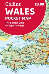
Wales Pocket Map
The Perfect Way to Explore Wales
Seiten
2019
Collins (Verlag)
978-0-00-832807-8 (ISBN)
Collins (Verlag)
978-0-00-832807-8 (ISBN)
- Titel erscheint in neuer Auflage
- Artikel merken
Zu diesem Artikel existiert eine Nachauflage
Explore new places with handy pocket maps from Collins.
Handy little full colour map of the whole of Wales. Excellent value and very detailed for its size.
Key features of this map include:
• Clear mapping at a scale of 3.9 miles to 1 inch
• Tourist attractions located
• Includes National parks and long distance paths
• Ideal companion to a sat-nav – it enables route planning and route sense-checking
Essential for those planning a trip or who want an inexpensive and easy-to-use back up for a sat-nav.
Explore the world through accurate and up-to-date mapping.
| Erscheint lt. Verlag | 7.3.2019 |
|---|---|
| Zusatzinfo | Index |
| Verlagsort | London |
| Sprache | englisch |
| Maße | 90 x 140 mm |
| Gewicht | 80 g |
| Themenwelt | Reisen ► Karten / Stadtpläne / Atlanten ► Europa |
| ISBN-10 | 0-00-832807-2 / 0008328072 |
| ISBN-13 | 978-0-00-832807-8 / 9780008328078 |
| Zustand | Neuware |
| Haben Sie eine Frage zum Produkt? |
Mehr entdecken
aus dem Bereich


aus dem Bereich
Straßen- und Freizeitkarte 1:250.000
Karte (gefalzt) (2023)
Freytag-Berndt und ARTARIA (Verlag)
12,90 €
Karte (gefalzt) (2023)
Freytag-Berndt und ARTARIA (Verlag)
12,90 €
Östersund
Karte (gefalzt) (2023)
Freytag-Berndt und ARTARIA (Verlag)
12,90 €