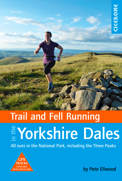
Trail and Fell Running in the Yorkshire Dales
Cicerone Press (Verlag)
978-1-85284-922-1 (ISBN)
Guidebook to 40 great trail and fell runs in the Yorkshire Dales National Park. Ranging from 5 to 24 miles, the graded runs start from bases such as Hawes, Settle, Ingleton, Dent, Sedbergh, Malham and Grassington and take in the region's diverse delights, from castles and waterfalls to iconic mountains such as Whernside, Ingleborough and Pen-Y-Ghent. For those seeking a longer challenge, the Pendragon Castle to Skipton Castle Ultra is also described.
In addition to clear route description, mapping and gradient profiles, the guide also provides background information on local races and running clubs, the history of running in the region, as well as practical information on safety, equipment, navigation, maps, transport and accommodation.
Sandwiched between the Lake District and the Pennines, the Yorkshire Dales showcases some of the finest running terrain in the British Isles. Offering a delightful mix of medium sized peaks and broad open moorland, it is a must-visit destination for those seeking off-road runs with enchanting views.
Pete Ellwood is an experienced fell runner, running and racing in the hills for over thirty years. He has lived in the North all his life and, from his teenage years, has attempted to spend every possible waking hour on the hills and mountains. Pete holds a long service award for volunteering as a member of a Mountain Rescue Team and 'compleated' the Munros in 2003. He regularly competes in fell races and mountain marathons in the North of England and Scotland, winning a class of the Saunders Mountain Marathon in 2013. Pete lives on the edge of the Yorkshire Dales with his wife, two boys and a daily view of Ingleborough to keep him company.
Map key
Overview map
Route summary table
Introduction
The Yorkshire Dales
History and geology
Nesting restrictions
Accommodation
Transport
Maps
Running in the Yorkshire Dales
A brief history
Tracks and trails
Three Peaks race
Running clubs
Equipment
Navigation
Safety and mountain rescue
Using this guide
The South-West Dales and Three Peaks
Route 1 Settle Loop
Route 2 Crummackdale
Route 3 Pen-y-ghent
Route 4 The Three Peaks (Pen-y-ghent, Whernside and Ingleborough)
Route 5 Gragareth
Route 6 Ingleborough (from the Old Hill Inn)
Route 7 Ingleborough (via Park Fell)
Route 8 Dodd Fell
Route 9 Cosh
Route 10 Great Knoutberry
Route 11 Whernside (from Ribblehead)
The North-West Dales and Howgills
Route 12 Dent to Ribblehead
Route 13 Whernside (from Dent)
Route 14 Barbondale
Route 15 Black Force (Howgills)
Route 16 Bowderdale
Route 17 Wild Boar Fell
Route 18 Cautley Spout
Route 19 Pendragon Castle to Skipton Castle Ultra Leg 1 (Pendragon Castle to Hawes)
The North-East Dales, Swaledale and Wensleydale
Route 20 Asygarth
Route 21 Thornton Rust
Route 22 Bainbridge
Route 23 Maiden Castle (Reeth)
Route 24 Gunnerside Gill
Route 25 Muker
Route 26 Great Shunner Fell
Route 27 Tan Hill (from Keld)
Route 28 Arkengarthdale
Route 29 Pendragon Castle to Skipton Castle Ultra Leg 2 (Hawes to Kettlewell)
The South-East Dales and Wharfedale
Route 30 Bolton Abbey
Route 31 Simon's Seat
Route 32 Malham Cove and Gordale Scar
Route 33 Mastiles Lane
Route 34 Grass Wood and Conistone Dib
Route 35 Troller's Gill
Route 36 Great Whernside (from Kettlewell)
Route 37 Fountains Fell
Route 38 Buckden Pike
Route 39 Masham Moor
Route 40 Pendragon Castle to Skipton Castle Ultra Leg 3 (Kettlewell to Skipton)
Appendix A Useful contacts
| Erscheinungsdatum | 18.03.2019 |
|---|---|
| Reihe/Serie | Cicerone guidebooks |
| Verlagsort | Kendal |
| Sprache | englisch |
| Maße | 116 x 172 mm |
| Gewicht | 270 g |
| Themenwelt | Sachbuch/Ratgeber ► Sport ► Leichtathletik / Turnen |
| Reisen ► Reiseführer | |
| Reisen ► Sport- / Aktivreisen ► Europa | |
| ISBN-10 | 1-85284-922-3 / 1852849223 |
| ISBN-13 | 978-1-85284-922-1 / 9781852849221 |
| Zustand | Neuware |
| Haben Sie eine Frage zum Produkt? |
aus dem Bereich
