Switzerland's Jura Crest Trail
Cicerone Press (Verlag)
978-1-85284-945-0 (ISBN)
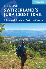
A guidebook to walking the Jura Crest Trail (also known as Crêtes du Jura or Jura High Route) between Dielsdorf near Zurich and Nyon on Lake Geneva. Covering 310km (193 miles), this long-distance trek traversing the sub-alpine mountains of the Swiss Jura takes around 2 weeks to walk and is suitable for any reasonably fit walker.
The route is described east to west in 14 stages, each between 12 and 32km (7–20 miles) in length. 12-, 16- and 21-day alternate itineraries are also outlined to allow you to plan the schedule that suits you.
1:100,000 maps included for each stage
Detailed information about accommodation, refreshments and public transport along the route
Advice on planning and preparation
Highlights include Creux du Van and the medieval towns of Baden and Brugg
Ali Rowsell is a full-time teacher who has worked internationally, in countries including Australia, South Korea and Switzerland. She specialises in the outdoors, in particular mountain walking, and is a freelance International Mountain Leader. Based in Sussex, Ali continues to venture into Switzerland on a regular basis: having lived in the southern part of the Jura, she is very familiar with the local area and enjoys summer and winter activities in the mountains around Lac de Joux.
Mountain safety
Route summary table
Map key
Overview map
Introduction
The Jura High Route
Geology of the Jura mountains
World War II and the Jura mountains
Flowers of the Jura mountains
When to go
Suggested itineraries
Getting there and around
Accommodation
Food and drink
Language
Money
What to take
Maps
Waymarking and trails
Safety in the mountains
Using this guide
The Jura High Route (East to West)
Stage 1 Dielsdorf to Neustalden
Stage 2 Neustalden to Hauenstein
Stage 3 Hauenstein to Balsthal
Stage 4 Balsthal to Weissenstein
Stage 5 Weissenstein to Frinvillier
Stage 6 Frinvillier to Chasseral
Stage 7 Chasseral to Vue des Alpes
Stage 8 Vue des Alpes to Noiraigue
Stage 9 Noiraigue to Sainte-Croix
Stage 10 Sainte-Croix to Vallorbe
Stage 11 Vallorbe to Col du Mollendruz
Stage 12 Col du Mollendruz to Col du Marchairuz
Stage 13 Col du Marchairuz to Saint-Cergue
Stage 14 Saint-Cergue to Nyon
Appendix A Accommodation
Appendix B Useful contacts
Appendix C Glossary
| Erscheinungsdatum | 14.01.2019 |
|---|---|
| Reihe/Serie | Cicerone guidebooks |
| Zusatzinfo | 15 maps, 70 colour photos |
| Verlagsort | Kendal |
| Sprache | englisch |
| Maße | 116 x 172 mm |
| Gewicht | 210 g |
| Themenwelt | Sachbuch/Ratgeber ► Sport |
| Reiseführer ► Europa ► Schweiz | |
| Reisen ► Sport- / Aktivreisen ► Europa | |
| ISBN-10 | 1-85284-945-2 / 1852849452 |
| ISBN-13 | 978-1-85284-945-0 / 9781852849450 |
| Zustand | Neuware |
| Haben Sie eine Frage zum Produkt? |