MARCO POLO Reiseatlas Frankreich 1:300.000
MAIRDUMONT (Verlag)
978-3-8297-3684-8 (ISBN)
- Titel erscheint in neuer Auflage
- Artikel merken
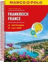
Der MARCO POLO Reiseatlas zeichnet sich durch moderne Kartographie aus und bildet Frankreich im optimalen Maßstab 1:300 000 ab. Mit Highlights aus Kultur und Natur und landschaftlich schönen Strecken wird dein Roadtrip damit zum echten Erlebnis. Länder- und Reiseinformationen bewahren dich vor dem Knöllchen, und das praktischen Zoom-System bietet von der Europakarte bis zum Stadtplan immer das richtige Kartendetail, sowohl für die Planung als auch während der Fahrt.
Marco Polo was the original, trailblazing 'tourist'. Born around 1254 into a wealthy Venetian merchant family, at the age of 17 he embarked on an epic journey to Asia and was one of the first westerners to visit China. When he returned he recorded his extensive travels by publishing a book which introduced Europeans to Central Asia and China, possibly the first 'travel guide' ever published! Marco Polo's travels have since inspired countless adventurers to set off and see the world. It is reputed that Christopher Columbus set off across the Atlantic with a copy of Marco Polo's original book. It is this pioneering spirit that drives us at Marco Polo Travel Publishing to provide the best guides, maps, atlases, and phrasebooks to help you explore the world. We hope our guides and maps will inspire you to set off on your own adventures. Pocket Guides Compact, colourful guides packed with Insider Tips and a free Touring App. Spiral Guides Itinerary-based guides in a unique, lay-flat spiral bound format. Travel Handbooks Visually inspiring, comprehensive guides offering detailed advice and informative infographics. Travel Journals Beautifully designed travel journals for use on the road. Phrasebooks Pocket-sized and packed with everyday phrases for confident communication. Folded Maps High quality touring maps with innovative Zoom system. City & Holiday Maps Compact, laminated maps with a detailed scale and maximum coverage. Road Atlases Clear, easy-to-read cartography in a handy spiral bound format. marcopologuides.com
"Blattübersichtskarte zum Ausklappen, Fernfahrtenkarte mit Kartenübersicht und Marco-Polo-Highlight-Sternen, Kartenübersicht mit Verwaltungsgliederung, Erläuterung des Zoomsystems (4-farbiges Leitsystem), Mehrsprachige Legende (F, D, GB, I, P, E, NL, PL, CZ, SK, SLO, HR), Marco-Polo-Highlights, Kartenteil Europa im Maßstab 1:4 500 000, Hauptkarten im Maßstab 1:300 000, 1 Transitkarte 1: 100 000: - Paris 22 Citypläne 1:20 000 mit mehrsprachiger Legende: - Paris - Avignon - Bordeaux - Brest - Dijon - Grenoble - Le Havre - Le Mans - Limoges - Lille - Lyon - Marseille - Monaco - Nancy - Nizza - Nimes - Orléans - Reims - Rennes - Rouen - Strasbourg - Toulouse Verkehrsinfos, Reiseinformationen, Liste der UNESCO-Welterbestätten, Ortsnamenverzeichnis mit Postleitzahl, Departement und Suchfeldangabe, Entfernungstabelle und Fahrzeiten."
| Erscheinungsdatum | 23.04.2018 |
|---|---|
| Reihe/Serie | MARCO POLO Reiseatlanten |
| Verlagsort | Ostfildern |
| Sprache | deutsch |
| Maße | 222 x 297 mm |
| Gewicht | 926 g |
| Themenwelt | Reisen ► Karten / Stadtpläne / Atlanten ► Europa |
| Reiseführer ► Europa ► Frankreich | |
| Schlagworte | Atlas Frankreich • Auvergne • Avignon • Bordeaux • Brest • Bretagne • Burgund • Champagne • Dijon • Disneyland Paris • Elsass • France road atlas, France atlas, Big road atlas Fr • France road atlas, France atlas, Big road atlas France, Road atlas France a4, Atlas of France, Motor • Frankreich • Gascogne • Grenoble • Karte Frankreich • Languedoc • Le Havre • Le Mans • Lille • Limoges • Lyon • Marseille • Monaco • NICE • Nimes • Nizza • Normandie • Orleans • Paris • Picardie • Poitou • Provence • Pyrenäen • Reims • Rouen • Straßburg • Toulouse |
| ISBN-10 | 3-8297-3684-3 / 3829736843 |
| ISBN-13 | 978-3-8297-3684-8 / 9783829736848 |
| Zustand | Neuware |
| Informationen gemäß Produktsicherheitsverordnung (GPSR) | |
| Haben Sie eine Frage zum Produkt? |