


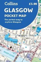
Glasgow Pocket Map
The Perfect Way to Explore Glasgow
Seiten
2018
Collins (Verlag)
978-0-00-828562-3 (ISBN)
Collins (Verlag)
978-0-00-828562-3 (ISBN)
- Titel erscheint in neuer Auflage
- Artikel merken
Zu diesem Artikel existiert eine Nachauflage
Explore new places with handy pocket maps from Collins.
Handy little full colour Collins map of central Glasgow with a high level of detail. Clear mapping from the park of Glasgow Green to the bustling West End. Map at a scale of 1:8200 (7.5 inches to 1 mile).
Clear, detailed, full colour Collins mapping is presented in a handy format ideal for the pocket or handbag. It is excellent value and covers the most visited area of central Glasgow. It is an essential buy for tourists and residents alike.
This map includes:
• Detailed central area map
• Around Glasgow map extending to airport, Pollok Park and Strathclyde Park
• Tourist locations
• Train and bus stations
• Listing of major places to visit
• Detailed street index
Explore the world through accurate and up-to-date mapping.
| Erscheint lt. Verlag | 8.3.2018 |
|---|---|
| Zusatzinfo | Index |
| Verlagsort | London |
| Sprache | englisch |
| Maße | 90 x 140 mm |
| Gewicht | 40 g |
| Themenwelt | Reisen ► Karten / Stadtpläne / Atlanten ► Europa |
| Reiseführer ► Europa ► Großbritannien | |
| ISBN-10 | 0-00-828562-4 / 0008285624 |
| ISBN-13 | 978-0-00-828562-3 / 9780008285623 |
| Zustand | Neuware |
| Haben Sie eine Frage zum Produkt? |
Mehr entdecken
aus dem Bereich


aus dem Bereich
Explore Scotland’s Ancient Monuments
Karte (gefalzt) (2024)
Collins (Verlag)
9,95 €