


Interactive Mobile ROADMAP Deutschland
Strassenkarte Deutschland 1:700 000
2017
High 5 Edition AG (Verlag)
978-3-906908-06-9 (ISBN)
High 5 Edition AG (Verlag)
978-3-906908-06-9 (ISBN)
Sobald der Benutzer den gewünschten Kartenausschnitt mit der High 5 Edition-App scannt, werden auf seinem Bildschirm Aktiv-Links sichtbar. Nach Antippen des gewünschten Links wird der Benutzer zu Plattformen mit zusätzlichen Informationen über Städte und touristische Sehenswürdigkeiten geführt. Er kann sich zudem die aktuellen Wetterdaten anzeigen lassen und seine eigenen Bilder auf die Karte projizieren. Somit wird der Atlas zum persönlichen Reisetagebuch.
lt;br />The first water-resistant roadmap with direct access to useful additional information from the Internet
Germany in a scale of 1:700,000 shown on a practical map; inclusive of the High 5 Edition app technology for calling up additional travel information and many other benefits:
practical format (11.4 x 23.5 cm)
it is water-resistant (laminated/cellophane coating)
the UNESCO World Heritage Sites are listed on the map
contains a selection of the local index including postal codes; the entire index can be viewed using the QR-code
It doesn't matter what weather it is used in or how often it is folded, the condition of the "ROADMAP Germany" will not deteriorate. Roads, ascents, woodland and mountain areas are easily recognisable thanks to the clear layout of the map. There is also a brief informative section about Germany (speed limits, area codes, emergency numbers, etc.)
The "Interactive Mobile ROADMAP Germany" - a "paper backup" just in case...
... and when used in conjunction with a smartphone, it is a great tool for planning trips.
What's not on the map is in the app
By scanning the section of the map you want with the High 5 Edition app, you can get a lot of useful additional information about major attractions and cities in Germany. The app is based on Augmented Reality technology and is available free of charge from the Apple App store and Google Play store. More information on www.high5edition.com
| Erscheint lt. Verlag | 1.7.2017 |
|---|---|
| Reihe/Serie | High 5 Edition ROADMAP Collection |
| Sprache | englisch; französisch; deutsch; italienisch |
| Maße | 114 x 235 mm |
| Gewicht | 115 g |
| Themenwelt | Reisen ► Karten / Stadtpläne / Atlanten ► Deutschland |
| Reisen ► Karten / Stadtpläne / Atlanten ► Europa | |
| Schlagworte | App • Deutschland, Karte; Autokarte/Straßenkarte • interaktiv • Reissfest • Strassenkarte • Straßenkarte • wasserfest |
| ISBN-10 | 3-906908-06-2 / 3906908062 |
| ISBN-13 | 978-3-906908-06-9 / 9783906908069 |
| Zustand | Neuware |
| Informationen gemäß Produktsicherheitsverordnung (GPSR) | |
| Haben Sie eine Frage zum Produkt? |
Mehr entdecken
aus dem Bereich
aus dem Bereich
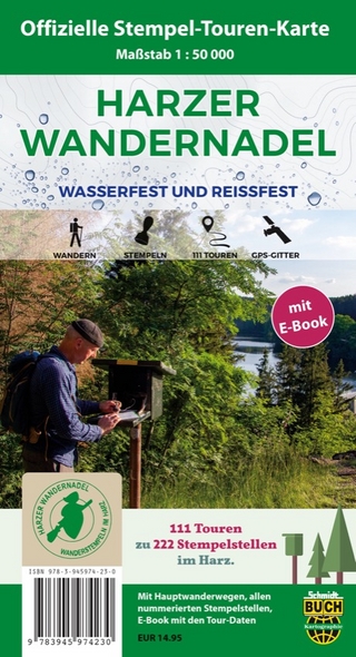
111 Touren zu 222 Stempelstellen – Die offizielle Touren-Karte
Karte (gefalzt) (2024)
Schmidt-Buch-Vlg (Verlag)
14,95 €
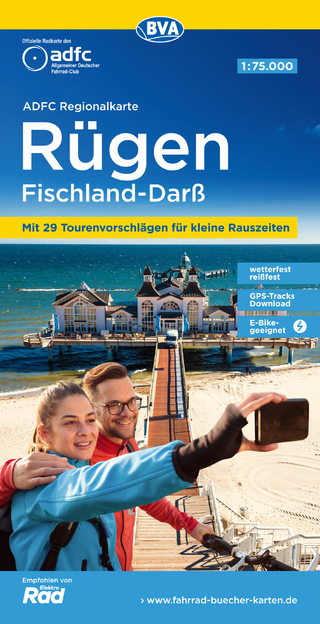
Karte (gefalzt) (2023)
BVA BikeMedia (Verlag)
10,95 €
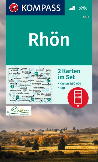
inklusive Karte zur offline Verwendung in der KOMPASS-App
Karte (gefalzt) (2023)
Kompass-Karten (Verlag)
13,95 €