The Swiss Alpine Pass Route - Via Alpina Route 1
Cicerone Press (Verlag)
978-1-85284-927-6 (ISBN)
- Titel erscheint in neuer Auflage
- Artikel merken
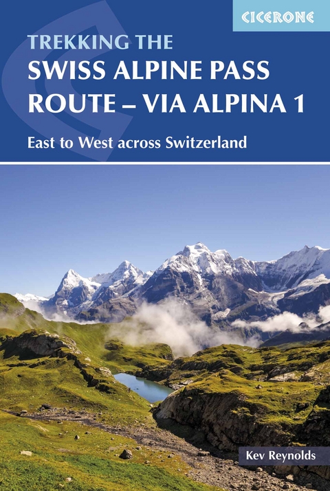
This guidebook presents the stunning Alpine Pass Route, now fully waymarked as Via Alpina 1. The 360km trail traverses Switzerland from east to west, from Sargans near the Liechtenstein border to Montreux on Lac Leman (Lake Geneva). Crossing sixteen Alpine passes, it showcases some of the country's most breathtaking mountain landscapes, boasting views of iconic peaks such as the Wetterhorn, Eiger, Jungfrau and Les Diablerets.
The route is suitable for those with some experience of Alpine trekking: it amasses over 20,000m of ascent and involves some steep sections. It can be completed in 2-3 weeks, although it is also possible to walk shorter sections; alternatively postbus, cable-car and rail connections could be used to allow for a tighter schedule.
The route is presented in 18 stages, each featuring step-by-step route description accompanied by 1:100,000 mapping, route profiles and notes on transport, accommodation and facilities. In addition, a 26km prologue in Liechtenstein and an alternative finish following the old course of the Alpine Pass Route via Gsteig are also described. Accommodation options range from mountain huts to hotels and inns, with camping available at a number of licensed sites along the route.
Kev Reynolds is a freelance writer, photojournalist and lecturer. A prolific compiler of guidebooks, his first title for Cicerone Press (Walks & Climbs in the Pyrenees) appeared in 1978; he has since produced many more titles. A member of the Outdoor Writers' Guild, the Alpine Club and Austrian Alpine Club, his passion for mountains and the countryside remains undiminished after a lifetime's activity, and he regularly travels throughout Britain to share that enthusiasm through his lectures.
Key to profiles
Map key
Overview map
Route summary table
Publisher's foreword
Preface
Introduction
The Swiss Alpine Pass Route
Suggested itineraries
When to go
Getting there - and back again
Accommodation
Languages
Notes for walkers
Paths and waymarks
Recommended maps
Safety in the mountains
Information at a glance
Using this guide
The Swiss Alpine Pass Route - Via Alpina Route
Prologue - The Liechtenstein start
Prologue A European Via Alpina Steg - Gaflei
Prologue B Via Alpina (red route 1) Gaflei - Sargans
The main route
Stage 1 Sargans - Mels - Weisstannen
Stage 2 Weisstannen - Foopass - Elm
Stage 3 Elm - Richetlipass - Linthal
Stage 4 Linthal - Braunwald - Urnerboden
Stage 5 Urnerboden - Klausenpass - Altdorf
Stage 6 Altdorf - Surenenpass - Engelberg
Stage 7 Engelberg - Jochpass - Engstlenalp
Stage 8 Engstlenalp - Planplatten - Meiringen
Stage 9 Meiringen - Grosse Scheidegg - Grindelwald
Stage 10 Grindelwald - Kleine Scheidegg - Lauterbrunnen
Stage 11 Lauterbrunnen - Mürren - Sefinenfurke - Griesalp
Stage 12 Griesalp - Hohtürli - Kandersteg
Stage 13 Kandersteg - Bunderchrinde - Adelboden
Stage 14 Adelboden - Hahnenmoospass - Lenk
Stage 15 Lenk - Trüttlisbergpass - Gstaad
Stage 16 Gstaad - Col de Jable - L'Etivaz
Stage 17 L'Etivaz - Col de Chaude - Rochers de Naye
Stage 18 Rochers de Naye - Sonchaux - Montreux
Alternative finish
Stage 15A Lenk - Lauenen - Gsteig
Stage 16A Gsteig - Blattipass - Col des Andérets - Col des Mosses
Stage 17A Col des Mosses - Col de Chaude - Montreux
Appendix A Useful addresses
Appendix B Bibliography
Appendix C German-French-English glossary
| Erscheinungsdatum | 25.05.2017 |
|---|---|
| Reihe/Serie | Cicerone guidebooks |
| Zusatzinfo | 91 colour photos, 23 maps and 22 profiles |
| Verlagsort | Kendal |
| Sprache | englisch |
| Maße | 116 x 172 mm |
| Gewicht | 260 g |
| Themenwelt | Sachbuch/Ratgeber ► Sport |
| Reiseführer ► Europa ► Schweiz | |
| Reisen ► Sport- / Aktivreisen ► Europa | |
| ISBN-10 | 1-85284-927-4 / 1852849274 |
| ISBN-13 | 978-1-85284-927-6 / 9781852849276 |
| Zustand | Neuware |
| Informationen gemäß Produktsicherheitsverordnung (GPSR) | |
| Haben Sie eine Frage zum Produkt? |
aus dem Bereich
