South West Coast Path Map Booklet - Vol 3: Plymouth to Poole
Cicerone Press (Verlag)
978-1-85284-962-7 (ISBN)
- Titel erscheint in neuer Auflage
- Artikel merken
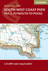
This booklet of Ordnance Survey 1:25,000 Explorer maps shows the full line of the section of the National Trail between Plymouth and Poole, providing all the mapping you need to walk the trail in either direction. It is conveniently sized for slipping into a jacket pocket or top of a rucksack.
Two separate booklets cover the route from Minehead to St Ives and from St Ives to Plymouth. The map booklets accompany the Cicerone guidebook - The South West Coast Path - which describes the full National Trail in 45 stages, with lots of other practical information and local points of interest.
The South West Coast Path is Britain's longest National Trail, stretching some 630 miles (1014km) between Minehead in Somerset and Poole in Dorset.
Paddy Dillon is a prolific outdoor writer with over 70 guidebooks to his name, and contributions to 30 other publications. He has written for a variety of outdoor magazines, as well as many booklets and brochures for tourism organisations. Paddy lives near the Lake District and has walked in every county in England, Scotland, Ireland and Wales; writing about walks in every one of them.
Contents
Key to map pages
Stage 31 Plymouth to Wembury Beach
Stage 32 Wembury Beach to Bigbury-on-Sea
Stage 33 Bigbury-on-Sea to Salcombe
Stage 34 Salcombe to Stoke Fleming
Stage 35 Stoke Fleming to Brixham
Stage 36 Brixham to Shaldon
Stage 37 Shaldon to Budleigh Salterton
Stage 38 Budleigh Salterton to Seaton
Stage 39 Seaton to Seatown
Stage 40 Seatown to Abbotsbury
Stage 41 Abbotsbury to Ferrybridge
Stage 42 Isle of Portland circuit
Stage 43 Ferrybridge to Lulworth Cove
Stage 44 Lulworth Cove to Swanage
Stage 45 Swanage to South Haven Point
South Dorset ridgeway
West Bexington to Osmington Mills
OS Explorer map legend
| Erscheinungsdatum | 01.11.2016 |
|---|---|
| Reihe/Serie | Cicerone guidebooks |
| Verlagsort | Kendal |
| Sprache | englisch |
| Maße | 116 x 172 mm |
| Gewicht | 150 g |
| Themenwelt | Sachbuch/Ratgeber ► Sport |
| Reisen ► Karten / Stadtpläne / Atlanten ► Europa | |
| Reiseführer ► Europa ► Großbritannien | |
| ISBN-10 | 1-85284-962-2 / 1852849622 |
| ISBN-13 | 978-1-85284-962-7 / 9781852849627 |
| Zustand | Neuware |
| Informationen gemäß Produktsicherheitsverordnung (GPSR) | |
| Haben Sie eine Frage zum Produkt? |
aus dem Bereich