Walking in the Haute Savoie: South
Cicerone Press (Verlag)
978-1-85284-811-8 (ISBN)
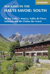
A guidebook to 30 walks in southern Haute Savoie. Exploring the dramatic scenery of the French Alps between Chamonix and Annecy, the walks are suitable for beginner and experienced walkers alike.
Routes range from 7 to 20km (4–12 miles) and can be enjoyed in 3–8 hours. Walks have been graded from easy to difficult allowing you to choose routes suitable for your ability.
1:50,000 maps are included for each route
GPX files available to download
Detailed information on planning, accommodation and transport
Part of a 2-volume set, an accompanying Cicerone guidebook Walking in the Haute Savoie: North is also available
Janette Norton lived in France, near Geneva, for over 30 years with her physicist husband, Alan, raising four children and working in the marketing field. Her love of mountain walking dated from the time she was a guide in her twenties, and the proximity of the Alps and Jura to her home inspired her to continue her passion. After her children grew up, she branched out to explore other areas of France.
Map key
Location of walks
Preface
Introduction
A short history of the Haute Savoie
Wildlife
Plants and flowers
Getting there
When to go
Accommodation
Savoyard food and drink
What to take
Waymarking
Maps
Safety
Using this guide
Vall&##xe9;e de l'Arve
Walk 1 Le Môle
Walk 2 Pointe de Marcelly
Walk 3 Tour de Chevran
Walk 4 Plateau d'Assy
Walk 5 Refuge de Moëde-Anterne
Vall&##xe9;e du Haut Giffre
Walk 6 Lac d'Anterne et le D&##xe9;rochoir
Walk 7 Lac de Gers
Walk 8 Lac de la Vogealle
Walk 9 T&##xea;te de Bostan
Walk 10 Chalets de Criou
Chaîne des Aravis: Nord
Walk 11 Lac B&##xe9;nit
Walk 12 Boucle des Confins
Walk 13 Trou de la Mouche
Walk 14 Circuit des Annes
Walk 15 Ar&##xea;te des Saix
Walk 16 Boucle du Lac de Lessy
Walk 17 Boucle de St-Jean-de-Sixt
Chaîne des Aravis: Sud
Walk 18 Pointe d'Orsi&##xe8;re
Walk 19 Tour de La Tulle
Walk 20 Tour du Sulens
Walk 21 Tour de l'Aiguille de la Tournette
Walk 22 Boucle des Tervelles
Plateau de la Borne
Walk 23 Roche Parnal
Walk 24 Montagne de Sous-Dîne
Walk 25 Plateau des Gli&##xe8;res
Walk 26 Le Parmelan
Lac d'Annecy
Walk 27 La Tournette
Walk 28 Cascades d'Angon
Walk 29 Cr&##xea;te du Taillefer
Walk 30 Montagne d'Entrevernes
Appendix A Route summary table
Appendix B Useful information
Appendix C Glossary of useful French words
| Erscheint lt. Verlag | 25.7.2024 |
|---|---|
| Reihe/Serie | Cicerone guidebooks |
| Überarbeitung | Alan Norton, Pamela Harris |
| Verlagsort | Kendal |
| Sprache | englisch |
| Maße | 116 x 172 mm |
| Gewicht | 300 g |
| Themenwelt | Sachbuch/Ratgeber ► Sport |
| Reiseführer ► Europa ► Frankreich | |
| Reisen ► Sport- / Aktivreisen ► Europa | |
| ISBN-10 | 1-85284-811-1 / 1852848111 |
| ISBN-13 | 978-1-85284-811-8 / 9781852848118 |
| Zustand | Neuware |
| Haben Sie eine Frage zum Produkt? |
aus dem Bereich