


Wales Road Map
Seiten
2018
|
7th edition
Geographers' A-Z Map Co Ltd (Verlag)
978-1-78257-074-5 (ISBN)
Geographers' A-Z Map Co Ltd (Verlag)
978-1-78257-074-5 (ISBN)
- Titel erscheint in neuer Auflage
- Artikel merken
Zu diesem Artikel existiert eine Nachauflage
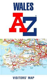
This A-Z map of Wales is a full colour fold-out road map showing the whole of Wales on one side. This map extends to also cover Liverpool to the north, Shrewsbury to the east and Weston-Super-Mare to the south.
Map detail is shown at a clear 2.2 kms to 1 cm (3.5 miles to 1 inch) and includes the following features:
•Clear standard road classification colours for easy identification
•Full motorway junction detail
•Under construction and proposed roads
•Primary route destinations
•Service areas
•National, county and unitary authority boundaries
•Selected safety camera locations with maximum speed limits
•Selected fuel stations
•National Park Boundaries for Snowdonia, Brecon Beacons and Pembrokeshire Coast
•Hill shading sourced from Geo-Innovations © www.geoinnovations.co.uk
•A wide range of tourist and ancillary information, including Blue flag Beaches
The index, on the reverse, lists cities, towns, villages, hamlets and locations featured on the map. The reference panel is shown in Welsh and English.
With Wales presented on one side this publication is particularly striking when laminated and mounted on a wall.
Britain’s leading street map publisher providing cartographic services, digital data products and paper mapping publications (including Street Atlases, Visitors Guides, Great Britain Road Atlases and The Adventure Atlas).
| Erscheint lt. Verlag | 3.9.2018 |
|---|---|
| Sprache | englisch |
| Maße | 110 x 214 mm |
| Gewicht | 148 g |
| Themenwelt | Sachbuch/Ratgeber |
| Reisen ► Karten / Stadtpläne / Atlanten ► Europa | |
| Naturwissenschaften ► Geowissenschaften ► Geografie / Kartografie | |
| ISBN-10 | 1-78257-074-8 / 1782570748 |
| ISBN-13 | 978-1-78257-074-5 / 9781782570745 |
| Zustand | Neuware |
| Haben Sie eine Frage zum Produkt? |
Mehr entdecken
aus dem Bereich


aus dem Bereich
Karte (gefalzt) (2023)
Freytag-Berndt und ARTARIA (Verlag)
12,90 €
Straßen- und Freizeitkarte 1:250.000
Karte (gefalzt) (2023)
Freytag-Berndt und ARTARIA (Verlag)
12,90 €
Östersund
Karte (gefalzt) (2023)
Freytag-Berndt und ARTARIA (Verlag)
12,90 €