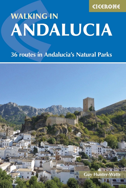
Walking in Andalucia
Cicerone Press (Verlag)
978-1-85284-802-6 (ISBN)
A guidebook to 36 walks in the natural and national parks of Spain’s Andalucía region. Graded by difficulty from easy strolls to strenuous mountain hikes, there are routes to suit both beginner and more experienced walkers alike.
Walks range from 4 to 21km (2–13 miles) and can be enjoyed in 2–7 hours. They are split between six diverse areas based on the six parks: Aracena, Grazalema, Los Alcornocales, La Axarquía (the coastal plain around Nerja, just south of the Almijara), Las Alpujarras (in the Sierra Nevada) and Cazorla.
Clear route description illustrated with 1:50,000 mapping
GPX files available for download
Information on bases and facilities
Local points of interest
Sized to easily fit in a jacket pocket
Guy Hunter-Watts has lived and worked in Andalucía since the 1980s. After studying at the universities of Santiago and Salamanca he taught English in South America before moving to the Ronda mountains, where he has been leading guided walks for almost 25 years. His work as a walking guide and freelance journalist has taken him to many corners of the planet including India, Namibia, Tanzania, Latin America and Mongolia.
Contents
Map Legend
Overview Map
Introduction
Aracena Regional Introduction
1. Aracena eastern circuit via Corteconcepción
2. Aracena western circuit via Linares
3. Al&##xe1;jar eastern circuit via Linares
4. Al&##xe1;jar western circuit via Castaño del Robledo
5. Almonaster circuit
6. Galoroza circuit via Castaño del Robledo
Grazalema Regional Introduction
1. Benaoj&##xe1;n Estación to Jimera de Libar
2. Montejaque circuit
3. Grazalema circuit via El Reloj & Simancón
4. Grazalema to Benaoc&##xe1;z
5. Grazalema northern circuit
6. Zahara de La Sierra circuit
Los Alcornocales Regional Introduction
1. Jimena western circuit
2. Jimena northern circuit
3. La Sauceda to Pico del Aljibe
4. Casares circuit
5. Gaucín western circuit
6. Benarrab&##xe1; circuit
La Axarquía Regional Introduction
1. Maro to Frigiliana via El Camino del Im&##xe1;n
2. Frigiliana to El Fuerte
3. Cómpeta eastern circuit
4. Cómpeta northern circuit
5. Canillas de Albaida circuit
6. Sayalonga circuit via Corumbela
Las Alpujarras Regional Introduction
1. Pampaneira circuit via Capileira & Bubión
2. Capileira circuit via the Poqueira Gorge
3. La Cebadilla High Acequias circuit
4. Bubión circuit via Junta de los Rios & Capilerilla
5. Ferreirola circuit via La Tah&##xe1;
6. Ferreirola circuit via Busqusitar
Cazorla Regional Introduction
1. Cazorla circuit via San Sebastian
2. Cazorla circuit via El Chorro
3. Cazorla circuit via El Gilillo
4. La Iruela circuit via Fuente del Oso
5. The Río Borosa gorge walk
6. Puente de Las Herrerias circuit via Poyos de la Mesa
Appendices
Appendix 1 Glossary
Appendix 2 Summary of routes
| Erscheint lt. Verlag | 17.9.2020 |
|---|---|
| Reihe/Serie | Cicerone guidebooks |
| Zusatzinfo | colour photographs and maps |
| Verlagsort | Kendal |
| Sprache | englisch |
| Maße | 116 x 172 mm |
| Gewicht | 280 g |
| Themenwelt | Sachbuch/Ratgeber ► Sport |
| Reiseführer ► Europa ► Spanien | |
| Reisen ► Sport- / Aktivreisen ► Europa | |
| ISBN-10 | 1-85284-802-2 / 1852848022 |
| ISBN-13 | 978-1-85284-802-6 / 9781852848026 |
| Zustand | Neuware |
| Informationen gemäß Produktsicherheitsverordnung (GPSR) | |
| Haben Sie eine Frage zum Produkt? |
aus dem Bereich
